
| Date | Name of Vessel |
Type of Vessel |
Tonnage JANAC |
Tonnage Alden |
Location | Assessment JANAC |
Assessment Alden |
|---|---|---|---|---|---|---|---|
| none | |||||||
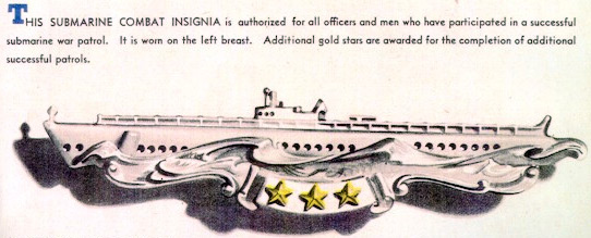
Award of Submarine Combat Insignia for this patrol is authorized.
(A) Prologue
(B) Narrative
(C) Weather
(D) Tidal Information
(E) Navigational Aids
(F) Ship Contacts
(G) Aircraft Contacts
(H) Attack Data
(I) Mines
(J) Anti-Submarine Measures and Evasion Tactics
(K) Major Defects and Damage
(L) Radio
(M) Radar
(N) Sound Gear and Sound Conditions
(O) Density Layers
(P) Health, Food, and Habitability
(Q) Personnel
(R) Miles Steamed - Fuel Used
(S) Duration
(T) Factors of Endurance Remaining
(U) Remarks
Arrived in Majuro, Marshall Islands from ninth war patrol on May 31, 1944 in good material condition. Normal refit, with no alterations or major work, was accomplished by U.S.S. SPERRY, and SubDiv 101.
Lieutenant V.U. Ransing, USNR, was detached and Lieutenant (jg) V.H. Johnson, USNR, and Lieutenant (jg) R.E. Nelson, USNR, reported aboard for duty. On June 23, 1944, the Commanding Officer, Commander D.F. Williamson, USN, was relieved by the former Executive Officer, Lieutenant Commander M.H. Rindskopf, USN.
Four days were spent in training during which three Mark 14 exercise torpedoes and all guns were fired.
Readiness for sea June 24, 1944.
| 24 June | |
| 1300 (L) | Departed Majuro for tenth war patrol in accordance with ComSubPac Operation Order No. 215-44 in company with U.S.S. MEADE (DD 602). |
| 25 June | |
| 0900 (L) | Parted company with escort, U.S.S. MEADE, and entered safety lane. |
| 25 June - 30 June | |
| Training dives and fire control drills held daily. | |
| 26 June | |
| 0415 (L) | Made SJ radar contact on Kusaie Island bearing 109°(T), distant 40 miles. |
| 28 June | |
| 1035 (L) | Sighted Betty, range 6 miles. (Aircraft Contact No. 1). Dove. |
| 1105 | Surfaced. |
| 29 June | |
| 1000 (L) | Changed to -10 zone time. |
| 1045 (K) | Sighted Mavis, range 10 miles. (Aircraft Contact No. 2). Dove. |
| 1115 | Surfaced. |
| 30 June | |
| 1210 (K) | Heavy interference on SD radar. (Radar Interference No. 1). Dove and routined torpedoes. |
| 1430 | Surfaced. |
| 1 July | |
| 0100 (K) | Entered Area 10-E. |
| 1240 | Sighted Yap Island bearing 265°(T), distant 30 miles. Patrolling between Yap and Ulitki Islands. |
| 1245 | 14 mile contact on SD. Did not sight. (Aircraft Contact No. 3). |
| 2 July | |
| 1510 (K) | 3 mile contact on SD. (Aircraft Contact No. 4). Dove. Heard one small bomb while passing 90 feet, not close. |
| 1547 | Heard two more bombs, farther away. |
| 1551 | Heard one more bomb, still farther. |
| 2000 | Surfaced. |
| 3 July | |
| 0616 (K) | Dove. |
| 1030 | Surfaced. Patrolling south of Yap. |
| 1140 | 22 mile contact on SD. (Aircraft Contact No. 5). |
| 1142 | Sighted 23 Liberators heading for Yap. Watched them make their bombing run and observed 3 enemy fighters counter-attacking. (Aircraft Contact No. 6). |
| 1215 | Liberators have completed their runs and are heading for home directly toward us with their fighters still harassing them - not too closely, however. We can count 23 bombers. One is leaving a trail of white smoke but is having no apparent difficulty maintaining formation. |
| 1220 | With the bombers directly overhead, one enemy fighter breaks away and runs up our port side, range 2 miles. |
| 1222 | Up on our port bow, enemy fighters signifies his intention by going into a steep bank, so we dive. On the way down, heard machine gun fire striking conning tower. We had not dived sooner because from appearances one bomber could have been in trouble and we would have been no help at periscope depth. |
| 1305 | Ran for two minutes with radio mast out listening on 4475 but heard nothing. |
| 1940 | Surfaced. The Nip did nick us! One projectile hit the wooden deck by the after 20mm and a couple hit the conning tower fairwater aft, and here is an oddity - all three of our radio antennas had been hit though none had parted. No serious damage. |
| 4 July | |
| 0610 (K) | Dove. |
| 1045 | Surfaced. |
| 1145 | 14 mile contact on SD. (Aircraft Contact No. 7). Sighted 15 Liberators heading for Yap. The bombers passed out of sight over the target area as they entered large cumulus clouds. |
| 1225 | Sighted the Liberators returning; counted 15 and no fighters. Called them on 4475 to ask if they anticipated a need for us but received no reply. |
| 1300 | Heading eastward at two engine speed to celebrate the 4th by bombarding Fais Island. |
| 2010 | Sighted Fais bearing 060°(T), distant 13 miles, in bright moonlight. |
| 2130 | Went to battle stations surface. |
| 2205 | Opened fire on Refinery Point with 4 inch at 4000 yards, closing to 1800 yards. Opened fire at 1500 yards with 20mm and 30 caliber machine guns and closed to 1100 yards. Extent of damage could not be determined but at least 42 4 inch and numerous 20mm and 30 caliber projectiles were observed to fall among buildings. (Gun Attack No. 1). As soon as the bombardment began, the shore radio station opened up frantically on 5420 Kilocycles. We were successful in jamming this until we had cleared area. |
| 2240 | Ceased firing. Set course to return to lifeguard station. |
| 5 July | |
| 0730 (K) | Sighted 8 to 12 Bettys, range 10 miles, heading for Yap. (Aircraft Contact No. 8). Dove. |
| 1045 | Surfaced. |
| 1500 | Sighted unidentified single engine plane, range 18 miles. (Aircraft Contact No. 9). |
| 1600 | Sighted unidentified single engine plane, range 10 miles. (Aircraft Contact No. 10). Dove as he turned towards us. |
| 1640 | Sighted plane of Contact No. 10 through periscope. He is suspicious for he appears to be searching this area. |
| 1709 | Sighted small trawler (75 tons) bearing 015°(T), range 4500 yards, on easterly course. (Ship Contact No. 1). |
| 1900 | The trawler did not go on his way but is still with us and is acting very suspiciously. He is not pinging but seems to know we are here. Apparently he cooperated with the plane which forced us down. |
| 2000 | We make the first of two attempts to surface. Three times, after we had finally located him, we put him astern. Contact would then soon be lost and as we would come to 40 feet he would turn up nearly dead ahead. We could no maintain sound contact with him but he apparently had no difficulty in keeping us located. |
| 2057 | Trawler finally sighted through periscope in growing moonlight, again up on our bow. Sound is coached on and he is put astern. |
| 2140 | Sight and sound contact lost astern. Surfaced. Trawler can be seen astern, range 3000 yards. In view of bright moon and his cooperation with the plane earlier today, will leave him alone. |
| 6 July | |
| 0230 (K) | Changed course to head for position of downed Liberator at full speed. |
| 0815 | Arrived at given position of downed aviators. It would help to know when they were here. As far as we know all the bombers from the raids observed by us returned safely. Commenced search to the westward at four engine speed. Consider this our best possibility because of easterly winds and westerly currents which have been prevalent. |
| 1217 | 10 mile contact on SD closing to 6 miles. (Aircraft Contact No. 11). Dove. Did not sight. |
| 1248 | Surfaced. Resumed search. |
| 1250 | Sighted 24 Liberators, range 25 miles, returning from Yap bombing. (Aircraft Contact No. 12). Again attempted communication but to no avail. They might have some information that would aid us in our search. |
| 2000 | Converted #4 F.B.T. to M.B.T. |
| 2200 | Dove to flush out #4. |
| 2220 | Surfaced. Resumed Search. |
| 7 July | |
| 0407 (K) | Made SJ radar contact in rain squall bearing 340°(T), range 12,100 yards. (Ship Contact No. 2). Determined target to be on course 230°(T) at 10 knots. Target was visible as he came out of rain squall in growing twilight. Appeared to be small PC type escort vessel. Broke off tracking and resumed search to eastward for aviators. |
| 1220 | Sighted Betty, range 8 miles. (Aircraft Contact No. 13). Dove. |
| 1250 | Surfaced. |
| 1315 | Sighted unidentified plane range 18 miles. (Aircraft Contact No. 14). Disappeared over horizon. |
| 1930 | Ceased search for Liberator crew having covered about 1400 square miles of ocean area. During the time of the search, the visibility was unlimited and the sea flat calm. Abandoned dugouts, tree trunks, etc., were sighted at a distance of 5 miles and it is felt that the area traversed was thoroughly covered. |
| 9 July | |
| 1200 (K) | Entered Area 10-F. |
| 1300 | Dove to service torpedoes. |
| 1600 | Surfaced. |
| 10 July | |
| 0133 (K) | Made SJ radar contact with Babelthaup Island, distant about 35 miles. |
| 0540 | Dove with range to nearest land 15 miles and commenced closing. Will patrol submerged off Malakal Pass today. |
| 0925 | Sighted float plane over Babelthaup. (Aircraft Contact No. 15). |
| 0930 | Sound and periscope picked up small fishing sampan. (Ship Contact No. 3). Numerous fishermen visible hard at work. |
| 1530 | We are now in a position so that we can see between Korror and Urukthapel Islands, into Malakal Harbor, but can see no signs of activity. |
| 2030 | Surfaced. Patrolling to the south. |
| 2254 | Made SJ radar contact, bearing 043°(T), range 15,000 yards. Pip was first seen on "A" scope and was maintained for about two minutes, long enough to lobe switch on it and see it on the PPI. Contact was not regained even after running down the bearing for 20 minutes at standard speed. In view of later events, it was probably a plane. |
| 11 July | |
| 0100 (K) | Entered Area 10-G. |
| 0200 | Made SJ radar contact bearing 295°(T), range 12,000 yards. Range closed quickly to 10,000 yards. (Aircraft Contact No. 16). |
| 0202 | Bright flare, bearing 195°(T), elevation 12° illuminated us. Dove. This may have been a radar equipped plane, although there had been no indications on APR nor interference on the SJ. The SD radar was not in use. Visibility was good with a 60% moon, elevation 40°, and about 0.4 cloud coverage. |
| 0242 | Surfaced. |
| 0554 | Dove southwest of Angaur Island, for submerged patrol. |
| 0745 | Sighted Angaur Island bearing 073°(T), distant 12 miles. |
| 1125 | Sighted unidentified plane, range 12 miles. (Aircraft Contact No. 17). |
| 1300 | Changed to -9 zone time. |
| 1245 (L) | Sighted Nell, range 5 miles. (Aircraft Contact No. 18). |
| 1522 | No activity observed on Angaur Island from a position about 2.5 miles off. Took pictures. |
| 1930 | Surfaced. As we surfaced, two searchlights began a ten minute search of the sky. |
| 2230 | Made SJ radar contact bearing 205°(T), range 15,000 yards and closing fast. (Aircraft Contact No. 19). |
| 2230 30" | With range 13,000 yards, dove. Last range 10,000 yards on way down. Tonight it is hard to conceive that we could have been visible from a plane. It is a clear, dark night with no moon and 0.4 cloud coverage, ceiling about 4000 feet. Our speed was 10 knots, leaving little wake. |
| 2300 | Surfaced. |
| 13 July | |
| Patrolling on surface southwest of the Palau Islands. | |
| 0725 (I) | Sighted Nell, range 8 miles. (Aircraft Contact No. 20). Dove. |
| 0800 | Surfaced. |
| 0920 | Sighted two unidentified medium bombers, range 15 miles. (Aircraft Contact No. 21). |
| 14 July | |
| 0445 (I) | Sighted Angaur Island, distant 19 miles. |
| 0500 | Dove and commenced closing Angaur. |
| 0635 | Sighted Jake, range 8 miles, circling Angaur. (Aircraft Contact No. 22). |
| 1035 | Sighted Nell, range 10 miles. (Aircraft Contact No. 23). |
| 1100 | Sighted unidentified plane, range 12 miles. We are now 6 miles from Angaur and there is no activity at the loading crane, although smoke from the railroad has been visible today. (Aircraft Contact No. 24). |
| 1130 | Sighted Jake, range 4 miles. (Aircraft Contact No. 25). |
| 1930 | Surfaced. |
| 15 July | |
| For the past few days SD results have been disappointing. Inspection showed grounded antenna mast which could not be cleared. SD was therefore not used for the remainder of the patrol. | |
| 1055 (I) | Heard - and then sighted flight of 6 Nells, range 3 miles, elevation 25°, heading for Palau. (Aircraft Contact No. 26). Dove. Apparently we were not sighted. Will stay down and routine torpedoes. |
| 1220 | Surfaced. |
| 1337 | Observed that we had an air escort - a Betty at a range of 3 miles, elevation 15°, on a parallel course. (Aircraft Contact No. 27). Dove. |
| 1445 | Surfaced. |
| 16 July | |
| 0415 (I) | Made SJ radar contact on Babelthaup Island, distant 28 miles. |
| 0450 | Dove with range to nearest land 20 miles and commenced closing. |
| 0825 | Sighted 7 medium bombers over Babelthaup Island, range 15 miles. (Aircraft Contact No. 28). |
| 1500 | We are now 4 miles off the reef near Toagel Mlungui and have seen nothing but birds. |
| 1930 | Surfaced. |
| 17 July | |
| 0350 (I) | Made SJ contact bearing 099°(T), range 9500 yards. (Ship Contact No. 4). Determined to be small patrol craft on southerly course. Worked around him to the north for we intend to patrol submerged off Toagel Mlungui again today. |
| 0450 | Dove with range to nearest land 19 miles and commenced closing. |
| 0550 | Visibility is poor, Babelthaup is obscured by rain clouds and it is impossible to fix our position. Will patrol further out until visibility improves. |
| 0745 | Sighted two Chidori class torpedo boats bearing 083°(T), range 5500 yards, angle on the bow 50° Port, coming out of a rain squall. (Ship Contact No. 5). Both Chidoris are pinging. They passed at a minimum range of 4200 yards. Last seen at a range of 6000 yards. |
| 0815 | Visibility has now decreased to 500 yards and it is raining heavily. |
| 1200 | Visibility is now good; land can be seen. |
| 1347 | Sighted one of the previous Chidoris bearing 093°(T), on his way back to Toagel Mlungui. Minimum range 7000 yards. (Ship Contact No. 6). |
| 1602 | Sighted "smoky" trawler bearing 265°(T), range 5000 yards, also heading for the pass. (Ship Contact No. 7). |
| 1930 | Surfaced and opened to the westward. |
| 18 July | |
| 0445 (I) | Dove with range to Babelthaup 22 miles, and commenced closing. |
| 0810-0816 | Heard three distant depth charges or bombs during six minute period. |
| 0823 | Sighted float plane, range 5 miles. (Aircraft Contact No. 29). He was observed patrolling off Toagel Mlungui until 0915. |
| 0925 | Heard pinging in direction of Toagel Mlungui. Maybe today is our day. |
| 0940 | Lost sound contact. Pass is covered by a rain squall and we will be soon. |
| 0955 | Squall is upon us; visibility zero. After this, the visibility never increased to over 3 miles. It became necessary to adopt a retiring course. Nothing further came of our contacts. |
| 1930 | Surfaced and retired to the westward. |
| 19 July | |
| 0440 (I) | Dove with range to Babelthaup 25 miles and commenced closing. Condition 4 sea and heavy swell make depth control difficult. Visibility only fair. |
| 1030 | Sea has slacked off and depth control is improved. Visibility is also slightly improved, but no activity can be seen. |
| 1930 | Surfaced and retired to the westward. |
| 20 July | |
| 0455 (I) | Dove with range to Babelthaup 17 miles and commenced closing. |
| 1040 | Sighted smoke in direction of Toagel Mlungui. |
| 1130 | Bearing of smoke indicates ship going south close to reef. We are north of pass. Smoke has been high indicating small ship at not too great a range. Nothing else seen or heard. |
| 1325 | Sighted Rufe, range 4 miles, patrolling off Toagel Mlungui. (Aircraft Contact No. 30). |
| 1330 | Sound contact bearing 125°(T), in direction of pass. Two vessels heard pinging. |
| 1340 | Sighted two Chidori class torpedo boats, range 8000 yards, angle on bow 80° starboard. (Ship Contact No. 8). |
| 1415 | Heard screws bearing 175°(T); sighted SC type patrol vessel range 6000 yards. He is not pinging. |
| 1425 | SC is showing small angle on the bow and has closed range to 3000 yards, but is showing no definite signs of having contacted us. He is apparently listening. Evaded at periscope depth. |
| 1515 | SC has returned to Toagel and Chidoris have disappeared to southwest and can no longer be heard. Last sound bearing was 240°(T). |
| 1930 | Surfaced. |
| 1935 | Sighted signaling in direction of Toagel Mlungui. Slowed to one-third and manned sound. Perhaps there is something coming out. |
| 2000 | No further developments; signaling has not been seen again. Possibly our Chidoris were returning at the time. Opened out to westward at 10 knots. |
| 21 July | |
| 1940 (I) | Typical SJ interference on the SJ radar; probably BALAO. |
| 2115 | Made contact on SJ radar bearing 174°(T), range 15,600 yards. (Ship Contact No. 9). Commenced tracking target. Target is not visible but from the PPI determined target group consists of one small ship with two escorts, both pinging. The target is zig-zagging on five minute legs on base course 250°. (See Anti-Sub Measures). One escort is stationed on each beam of the target distant about 1000 yards. The escorts are not patrolling station but remain on a steady course and as the target zigs toward one the range decreases to less than 500 yards. |
| 22 July | |
| 0115 (I) | Manned battle stations for night attack on surface. Commenced attack. (Torpedo Attack No. 1). |
| 0135 | Commenced firing four torpedoes from stern tubes, torpedo run 1450 yards, gyro angles practically zero. |
| 0139 | Heard first of four end of run explosions at proper intervals. Target is seen to turn toward while escorts continue to maintain station. We withdraw at full speed and attempt to figure out how we missed a theoretically perfect shot - it is inexplainable. |
| 0145 | Running ahead to gain position for second attack. Have had intermittent SJ interference since 1940 so we send a contact report on 450 Kilocycles. Receipted for by BALAO. |
| 0300 | Visibility is considerably improved and from a range of 5000 yards target has the appearance of a floating box car. Will not make another night attack but will dive ahead and have a look at him in daylight. |
| 0546 | With range to target group about 15 miles, dove. |
| 0600 | Sound hears two escorts pinging. |
| 0620 | Manned battle stations submerged. |
| 0635 | Target group is now visible. The target is a yard oiler, escorted by one PC and one SC. Two or three of our torpedoes must have run under him. |
| 0640 | Evading to get off the target's track. Nearest escort passed at minimum range of 2500 yards. |
| 0800 | Surfaced and commenced patrol to the north. Transmitted Drum #1. |
| 24 July | |
| 1010 (I) | Sighted unidentified plane, range 5 miles. (Aircraft Contact No. 31). Dove. |
| 1100 | Surfaced. |
| 25 July | |
| 0915 (I) | Sighted Kate, range 6 miles. (Aircraft Contact No. 32). Dove. |
| 1000 | Surfaced. |
| 1425 | Sighted Betty, range 10 miles. (Aircraft Contact No. 33). Dove. |
| 1500 | Surfaced. |
| 1630 | Sighted Sally, range 4 miles. (Aircraft Contact No. 34). Dove. |
| 1815 | Surfaced and set course for lifeguard station near Peleliu Island. |
| 1930 | Typical SJ interference on SJ radar. Received intermittently throughout the night. |
| 26 July | |
| 0300 (I) | Made SJ radar contact bearing 107°(T), range 5600 yards. Commenced tracking target; it is probably BALAO as we received strong SJ interference on targets bearing intermittently. Unable to challenge him by keying SJ transmitter because his radar does not remain on long enough. (Learned later BALAO was having SJ difficulties.) (Ship Contact No. 10). |
| 0400 | Made SJ radar contact on Angaur Island, range 15 miles. |
| 0500 | Angaur, Peleliu, and Urukthapel Islands are now visible. |
| 0530 | Exchanged calls with BALAO, our 0300 radar contact. We had been on parallel course at about same speed since that time. |
| 0550 | On assigned lifeguard station with BALAO, bearing 270°(T), distant 10 miles from Peleliu Islands. |
| 0615 | BALAO dives and we follow suit - she has an SD radar and we don't. |
| 0620 | Observed AA fire and smoke over Peleliu; the carrier strike must have begun. |
| 0622 | Surfaced. BALAO surfaces soon after. |
| 0630 | Can see numerous TBF's over islands and we have two covering us. We can see several smoke columns over Peleliu, several in the Korror area and one over Angaur. |
| 0710 | No planes visible now. We could see no enemy fighter opposition to the first carrier strike and the AA fire seemed spasmodic and ineffectual. |
| 0720 | Received call for lifeguard vessel. Given position is very near Malakal Pass on other side of islands. Set course to round Angaur at flank speed. |
| 0810 | Sighted 2 Nells, range 5 miles. (Aircraft Contact No. 35). We have no cover now so dove. |
| 0830 | Surfaced and resumed course for position of downed aviators at flank speed. |
| 0835 | We now have a Wildcat to escort us. Communication with the planes leaves nothing to be desired. |
| 1029 | Sighted tops of two ships bearing 070°(T), range 12 miles. Identified as Fletcher class destroyers. (Ship Contact No. 11). |
| 1040 | Exchanged calls with the U.S.S. GATLING (DD 671) and U.S.S. DORTCH (DD 670). GATLING tells us she will rescue aviators. Fifteen more minutes and we would have had them! |
| 1100 | As the BALAO is effectively covering west of the islands, we request permission from the GATLING, who is in charge of lifeguard operations, to remain east of the islands. Affirmative from GATLING. The remainder of the day we patrol 6 to 10 miles from the reef from Peleliu to Korror. TBF's and SB2C's are making shuttle trips between their carriers and the islands. We have an F6F cover all afternoon. |
| 1630 | No more air activity; show is over for the day. Peleliu is still smoking and several columns of smoke are seen rising from the vicinity of Korror, probably from within Malakal Harbor. |
| 2300 | Made SJ radar contact bearing 000°(T), initial range 16,000 yards. (Aircraft Contact No. 36). Range closes to 11,000 yards and we dive. There is no moon and visibility is poor; another radar search plane. |
| 2330 | Surfaced. |
| 27 July | |
| 0530 (I) | On lifeguard station 10 miles east of Palau Islands with GATLING and DORTCH 4 to 6 miles outside. First wave of carrier planes can be seen approaching. As yesterday, shuttle trips were in progress throughout the day. We were continuously covered by one and sometimes two fighters. |
| 0925 | Bomb hit produces explosion with flames and smoke high into the air in direction of Malakal Harbor; probably from Malakal Island itself where the fuel dumps are located. Large columns of smoke were seen from this spot until the next evening when we left area. |
| 0930 | U.S.S. GATLING closes and takes our US Mail and gives us some badly needed flashlight bulbs and batteries. DORTCH has left to rendezvous with BALAO. |
| 1000 | GATLING departed lifeguard station. |
| 1430 | Our fighter cover departs; only a few planes over target area now. |
| 1515 | Sighted tops of ships of task force bearing 140°(T), distant about 17 miles. (Ship Contact No. 12). Carrier planes can be seen circling for landing. |
| 1800 | Set course to rendezvous with BALAO west of Angaur. |
| 1840 | Sighted unidentified plane over Angaur Island, range 20 miles. (Aircraft Contact No. 37). |
| 28 July | |
| 0450 | Made SJ radar contact bearing 200°(T), range 10,000 yards. Commenced tracking. |
| 0520 | Identified target as BALAO; exchanged recognition signals. |
| 0640 |
Sighted Angaur Island bearing 084°(T), distant 16 miles. Patrolling in Class D Area east of Peleliu in company with U.S.S. BALAO. |
| 29 July | |
| 0900 | Parted company with BALAO after agreeing to exchange contact reports should either of us develop anything. |
| 1225 | Sighted two sampans bearing 060°(T), range 5 miles on northwesterly course. (Ship Contact No. 13). Visibility is poor and sampans will soon be obscured by rain. We are on their beam, and must work ahead. BALAO is notified of contact. |
| 1326 | On sampan's track. Visibility is less than 2500 yards; targets have not been seen since initial contact. |
| 1416 | Made SJ radar contact bearing 255°(T), range 10,000 yards. This is BALAO for we have had her interference since 1300. Sighted her at 8000 yards. |
| 1430 | Informed BALAO that we will search to right of track while she anchors line. After contact, we will dive and attack from the quarter and she will then attack from the bow. Visibility is now improving. |
| 1506 | Sighted sampan bearing 117°(T), range 12,000 yards, angle on the bow is small port. Notified BALAO and dove. Commenced closing track. |
| 1530 | Sighted both sampans. They are small and do not appear to be armed. They resemble schooners with the masts cut off. |
| 1634 | Battle surfaced. Commenced firing all guns. (Gun Attack No. 2). |
| 1715 | Ceased firing. Our sampan is afire and blazing merrily as is BALAO's. Numerous survivors can be seen in water. We will attempt to get two prisoners. |
| 1730 | Two prisoners aboard. One, Chono Natsumori, is a member of the crew of Number One Nissyo Maru, our target and the other, Keiei Shimochi, is a fisherman. The fisherman has many shrapnel wounds. They were the only two of about 20 survivors who would come aboard. |
| 1745 | Again parted company with BALAO. Much credit for the second sighting of the sampans goes to the BALAO. Without her at one end of the search line the sampans might easily have passed to the eastward outside our visibility circle. |
| 31 July | |
| 1800 (I) | Departed area in accordance with operation order. |
| 2 August - 3 August | |
| Encountered typhoon west of Mariannas. (See Weather). | |
| 10 August | |
| 0040 (M) | Crossed International Date Line; changed date to August 9. |
| 0730 (Y) | Sighted PBY. |
| 1220 | Sighted 4 Midway SBD's. |
| 1305 | Sighted Midway Island. |
| 1435 | Moored at Submarine Base, Midway Island. Received 20,000 gallons diesel oil. |
| 10 August | |
| 1400 (Y) | Underway for Pearl Harbor in company with U.S.S. TAUTOG. |
| 14 August | |
| 0645 (VW) | Rendezvous with PC 1077. |
| 1000 | Moored at Submarine Base, Pearl Harbor, T.H. |
In the Yap-Ulithi area, weather was generally good although the cloud cover was usually 0.8 to 0.9. The breeze was consistently easterly and the visibility was good.
Near the Palau Islands, much squally weather was encountered. Cloud cover was usually 0.10. Sea was generally condition 2 to calm.
After leaving station, a typhoon was encountered west of the Mariannas. Wind velocity increased to 35 knots and sea to condition 6. The barometer dropped to a minimum of 2935 as the center passed north of us. From every indication, the typhoon, at 1700Z, 2 August, was centered near 23° N. and 140° E., while despatch information located its center at 20° N. and 133° E. at this time.
In the Yap-Ulithi area, the set was consistently westerly; drift about one knot.
West of the Palau Islands (60 to 100 miles offshore) the set was southwesterly; drift 0.4 knot.
Close to Angaur's west coast a southeasterly set, drift 0.7 knot was encountered.
The current off Toagel Mlungui was affected by the contour of the reef. North of the pass the current was westerly, and as the point of the reef south of the pass was approached, the current became southwesterly. A 2 knot set was encountered off the pass.
Lighthouses at Urukthapel, Angaur, and on the northern tip of Babelthaup were sighted but were not lighted.
Good fixes were obtained off Toagel Mlungui using the lighthouse on the north tip of Babelthaup, Hill 794 (small house on top), Hill 643, Hill 669 (Urukthapel), and Hill 393 (Apurashokoru).
H.O. chart No. 6073 was used and is far superior to any charts of the area previously issued, including Restricted #10394. The landmarks are well described in SEAHORSE first, GURNARD second, and GAR tenth war patrols.
| No. | Date | Time | Lat. North |
Long. East |
Description | Course True |
Speed RPM |
Init. Range | Min. Range | How Contact | Remarks |
|---|---|---|---|---|---|---|---|---|---|---|---|
| 1. | 5 Jul. | 1907 (K) | 8-54 | 138-25 | Trawler | 090° | 6 knots | 4500 yds. | 1800 yds. | P | Cooperated with search plane. |
| 2. | 7 Jul. | 0407 | 7-21 | 139-00 | Patrol Craft | 280° | 10 knots | 12,100 yds. | 10,000 yds. | R | Tracked to determine course & speed. |
| 3. | 10 Jul. | 0930 | 7-15 | 134-40 | Sampan | Var. | 4 knots | 5000 yds. | 1000 yds. | Sound P |
Observed crew fishing. |
| 4. | 17 Jul. | 0350 (I) | 7-39 | 134-01 | Patrol Craft | Southerly | - | 9500 yds. | 8400 yds. | R | Not seen at minimum range, visibility fair. |
| 5. | 17 Jul. | 0745 | 7-42 | 134-18 | 2 Chidoris | 335° | 12 knots | 5000 yds. | 4200 yds. | P | Came out of rain and disappeared as visibility decreased. |
| 6. | 17 Jul. | 1347 | 7-40 | 134-20 | 1 Chidori | 150° | 12 knots | 8000 yds. | 7000 yds. | P | Heading for Toagel Mlungui. |
| 7. | 17 Jul. | 1602 | 7-?3 | 134-17 | 1 Trawler | 135° | 8 knots | 5000 yds. | 5000 yds. | P | Heading for Toagel Mlungui. |
| 8. | 20 Jul. | 1330 | 7-38 | 134-25 | 2 Chidori 1 SC |
240° Var. |
14 knots 6 knots |
8000 yds. 6000 yds. |
7000 yds. 3000 yds. |
Sound | Came from Toagel Mlungui & disappeared on course 240°(T). Made sweep near Toagel Mlungui. |
| 9. | 21 Jul. | 2115 | 7-05 | 131-52 | 1 Yard Oiler 1 SC & 1 PC |
250° | 12 knots 10 knots |
15,600 yds. | 1800 yds. | R | Torpedo Attack No. 1. Identified after attack next morning through periscope. |
| 10. | 26 Jul. | 0300 | 7-00 | 134-00 | BALAO | 090° | 10 knots | 5600 yds. | 1000 yds. | R | Rendezvous with BALAO for lifeguard duties. |
| 11. | 26 Jul. | 1029 (I) | 7-12 | 134-28 | Fletcher class DD's | Var. | Var. | 20,000 yds. | 2000 yds. | SD | U.S.S. GATLING (DD-671) U.S.S. DORTCH (DD-670) lifeguard DD's. |
| 12. | 27 Jul. | 1515 | 7-02 | 134-40 | Task Force | - | - | 35,000 yds. | 32,000 yds. | SD | Friendly Task Force recovering planes. |
| 13. | 29 Jul. | 1634 | 9-18 | 133-20 | 2 Motor Sampans | 340° | 6.5 knots | 10,000 yds. | 400 yds. | SD | Made coordinated Gun Attack with BALAO. |
| Contact Number | 1. | 2. | 3. | 4. | 5. | 6. | 7. | 8. | 9. | 10. |
|---|---|---|---|---|---|---|---|---|---|---|
| SUBMARINE | ||||||||||
| Date | 28 Jun. | 29 Jun. | 1 Jul. | 2 Jul. | 3 Jul. | 3 Jul. | 4 Jul. | 5 Jul. | 5 Jul. | 5 Jul. |
| Time | 1040 (I) | 1045 (K) | 1245 | 1512 | 1140 | 1210 | 1145 | 0730 | 1500 | 1600 |
| Lat. N. | 4-53 | 5-20 | 9-37 | 9-12 | 9-01 | 9-00 | 9-15 | 9-04 | 8-54 | 8-52 |
| Long. E. | 152-11 | 146-52 | 138-58 | 138-28 | 138-35 | 138-32 | 138-56 | 139-10 | 138-30 | 138-27 |
| Speed | 15 k | 15 k | 10 k | 10 k | 10 k | 10 k | 10 k | 10 k | 10 k | 10 k |
| Course | 272° | 272° | 270° | 200° | 260° | 260° | 090° | 270° | 200° | 270° |
| Trim | Surf. | Surf. | Surf. | Surf. | Surf. | Surf. | Surf. | Surf. | Surf. | Surf. |
| Min. Since Last SD Radar Search |
1 | 1 | 0 | 0 | 0 | 1 | 0 | 1 | 1 | 1 |
| AIRCRAFT | ||||||||||
| Number | 1 | 1 | 1 | 1 | 23 | 3 | 15 | 9 | 1 | 1 |
| Type | Betty | Mavis | -- | -- | B-24 | Oscar | B-24 | Betty | Unid. | Unid. |
| Probable Mission | Patrol | Patrol | Patrol | Patrol | Bomb | Attack B-24 |
Bomb | Trans. | Patrol | Patrol |
| How Contacted | Sight | Sight | SD | SD | SD | Sight | SD | Sight | Sight | Sight |
| Initial Range | 6 miles | 10 miles | 14 miles | 3 miles | 22 miles | 20 miles | 14 miles | 10 miles | 18 miles | 10 miles |
| Elevation Angle | 2° | 2° | -- | -- | 5° | 12° | 10° | 5° | 1° | 1° |
| Range & Rel. Bearing of Plane When it Detected Sub |
ND | ND | ND | ND | ND | ND | ND | ND | ND | 000° 10 mi. |
| CONDITIONS | ||||||||||
| Sea State (Beaufort) |
0 | 2 | 1 | 1 | 1 | 1 | 2 | 1 | 1 | 1 |
| Sea Direction-Rel. | 135° | 270° | 090° | 090° | 090° | 080° | 090° | 090° | ||
| Visibility (Miles) | 8 | 30 | 30 | 40 | 40 | 40 | 40 | 40 | 40 | 40 |
| Clouds Height in Ft. | 1200 | 2000 | 1500 | 1000 | 1500 | 1500 | 1500 | 2500 | 2000 | 2000 |
| Clouds % Overcast | 100 | 60 | 70 | 100 | 3 | 3 | 4 | 7 | 7 | 7 |
| Moon Bearing-Rel. | ||||||||||
| Moon Angle | ||||||||||
| Moon % Illum. | ||||||||||
Aircraft Contacts Continued...
| Contact Number | 11. | 12. | 13. | 14. | 15. | 16. | 17. | 18. | 19. | 20. |
|---|---|---|---|---|---|---|---|---|---|---|
| SUBMARINE | ||||||||||
| Date | 6 Jul. | 6 Jul. | 7 Jul. | 7 Jul. | 10 Jul. | 11 Jul. | 11 Jul. | 11 Jul. | 11 Jul. | 13 Jul. |
| Time | 1217 | 1250 | 1220 | 1315 | 0935 | 0200 | 1125 | 1245 (I) | 2230 | 0725 |
| Lat. N. | 7-03 | 7-04 | 7-10 | 7-10 | 7-15 | 6-30 | 6-53 | 6-53 | 6-20 | 6-38 |
| Long. E. | 138-36 | 138-36 | 139-35 | 139-20 | 134-40 | 134-06 | 134-00 | 134-03 | 133-40 | 131-35 |
| Speed | 16 k | 10 k | 10 k | 10 k | 2 k | 10 k | 2 k | 2 k | 10 k | 10 k |
| Course | 000° | 000° | 300° | 270° | 260° | 210° | 073° | 080° | 210° | 325° |
| Trim | Surf. | Surf. LT | Surf. | Surf. | Per. | Surf. | Per. | Per. | Surf. | Surf. |
| Min. Since Last SD Radar Search |
0 | 1 | 1 | 1 | -- | Not in use | -- | -- | Not in use | 1 |
| AIRCRAFT | ||||||||||
| Number | 1 | 24 | 1 | 1 | 1 | 1 | 1 | 1 | 1 | 1 |
| Type | Unid. | B-24 | Betty | Unid. | Float Plane | Unid. | Unid. | Nell | Unid. | Nell |
| Probable Mission | Patrol | Bomb | Patrol | Patrol | Patrol | Patrol | Patrol | Patrol | Patrol | Patrol |
| How Contacted | SD | Sight | Sight | Sight | Sight | SJ | Sight | Sight | SJ | Sight |
| Initial Range | 10 miles | 25 miles | 8 miles | 18 miles | 10 miles | 6 miles | 12 miles | 5 miles | 7.5 miles | 8 miles |
| Elevation Angle | -- | 2° | 10° | 1/4° | 2° | 12° Flare | 1/4° | 4° | -- | 2° |
| Range & Rel. Bearing of Plane When it Detected Sub |
ND | ND | ND | ND | ND | 070° 5 mi. |
ND | ND | 355° 10 mi. |
ND |
| CONDITIONS | ||||||||||
| Sea State (Beaufort) |
1 | 1 | 1 | 1 | 2 | 1 | 0 | 0 | 2 | 1 |
| Sea Direction-Rel. | 090° | 090° | 090° | 090° | 135° | 045° | 020° | 300° | ||
| Visibility (Miles) | 40 | 40 | 40 | 40 | 40 | 15 | 40 | 40 | 8 | 40 |
| Clouds Height in Ft. | 1500 | 1500 | 1500 | 1500 | 2000 | 2100 | 2500 | 2500 | 4000 | 2500 |
| Clouds % Overcast | 6 | 6 | 9 | 9 | 6 | 4 | 4 | 4 | 4 | 4 |
| Moon Bearing-Rel. | 340° | |||||||||
| Moon Angle | 39° | No moon | ||||||||
| Moon % Illum. | 60% | |||||||||
Aircraft Contacts Continued...
| Contact Number | 21. | 22. | 23. | 24. | 25. | 26. | 27. | 28. | 29. | 30. |
|---|---|---|---|---|---|---|---|---|---|---|
| SUBMARINE | ||||||||||
| Date | 13 Jul. | 14 Jul. | 14 Jul. | 14 Jul. | 14 Jul. | 15 Jul. | 15 Jul. | 16 Jul. | 18 Jul. | 20 Jul. |
| Time | 0920 | 0635 | 1035 | 1100 | 1130 | 1055 | 1337 | 0825 | 0900 | 1325 |
| Lat. N. | 6-43 | 6-50 | 6-51 | 6-51 | 6-52 | 7-00 | 7-09 | 7-36 | 7-42 | 7-38 |
| Long. E. | 133-57 | 134-01 | 134-02 | 134-01 | 131-49 | 132-01 | 134-19 | 134-17 | 134-20 | 131-35 |
| Speed | 10 k | 2 k | 2 k | 2 k | 2 k | 10 k | 10 k | 2 k | 2 k | 2 k |
| Course | 180° | 030° | 060° | 060° | 330° | 055° | 055° | 170° | 130° | 090° |
| Trim | Surf. | Per. | Per. | Per. | Per. | Surf. | Surf. | Per. | Per. | Per. |
| Min. Since Last SD Radar Search |
1 | -- | -- | -- | -- | 0 | 1 | -- | -- | -- |
| AIRCRAFT | ||||||||||
| Number | 2 | 1 | 1 | 1 | 1 | 6 | 1 | 7 | 1 | 1 |
| Type | Med. Bomb. | Jake | Nell | Unid. | Jake | Nell | Betty | Med. Bomb. | Float | Rufe |
| Probable Mission | Patrol | Patrol | Patrol | Patrol | Patrol | Trans. | Trans. | Patrol | Patrol | Patrol |
| How Contacted | Sight | Sight | Sight | Sight | Sight | Sight | Sight | Sight | Sight | Sight |
| Initial Range | 15 miles | 8 miles | 10 miles | 12 miles | 4 miles | 3 miles | 2 miles | 15 miles | 5 miles | 4 miles |
| Elevation Angle | 3/4° | 1/2° | 1/2° | 1/2° | 1/2° | 25° | 15° | 1 1/2° | 3° | 3° |
| Range & Rel. Bearing of Plane When it Detected Sub |
ND | ND | ND | ND | ND | ND | ND | ND | ND | ND |
| CONDITIONS | ||||||||||
| Sea State (Beaufort) |
1 | 1 | 1 | 1 | 0 | 2 | 1 | 0 | 2 | 2 |
| Sea Direction-Rel. | 030° | 340° | 300° | 300° | -- | 260° | 240° | -- | 090° | 150° |
| Visibility (Miles) | 40 | 30 | 30 | 30 | 40 | 40 | 40 | 40 | 15 | 8 |
| Clouds Height in Ft. | 2500 | 1500 | 2500 | 2500 | 2500 | 3000 | 4000 | 2500 | 2000 | 1500 |
| Clouds % Overcast | 4 | 10 | 7 | 7 | 6 | 3 | 7 | 6 | 9 | 7 |
| Moon Bearing-Rel. | ||||||||||
| Moon Angle | ||||||||||
| Moon % Illum. | ||||||||||
Aircraft Contacts Continued...
| Contact Number | 31. | 32. | 33. | 34. | 35. | 36. | 37. |
|---|---|---|---|---|---|---|---|
| SUBMARINE | |||||||
| Date | 24 Jul. | 25 Jul. | 25 Jul. | 25 Jul. | 26 Jul. | 26 Jul. | 27 Jul. |
| Time | 1010 | 0915 | 1425 | 1625 | 0810 | 2300 | 1840 |
| Lat. N. | 6-50 | 7-36 | 7-05 | 7-05 | 6-?? | 7-15 | 6-40 |
| Long. E. | 131-59 | 131-50 | 132-37 | 132-49 | 134-?3 | 134-55 | 134-35 |
| Speed | 10 k | 10 k | 15 k | 10 k | 18 k | 5 k | 10 k |
| Course | 155° | 170° | 092° | 092° | 200° | 000° | 225° |
| Trim | Surf. | Surf. | Surf. | Surf. | Surf. | Surf. | Surf. |
| Min. Since Last SD Radar Search |
0 | 0 | 0 | 0 | 0 | 0 | 0 |
| AIRCRAFT | |||||||
| Number | 1 | 1 | 1 | 1 | 2 | 1 | 1 |
| Type | Unid. | Kate | Betty | Sally | Nell | Unid. | Unid. |
| Probable Mission | Patrol | Patrol | Patrol | Patrol | Trans. | Patrol | Patrol |
| How Contacted | Sight | Sight | Sight | Sight | Sight | SJ | Sight |
| Initial Range | 5 miles | 6 miles | 10 miles | 4 miles | 5 miles | 8 miles | 20 miles |
| Elevation Angle | 6° | 7° | 8° | 15° | 4° | -- | 1/4° |
| Range & Rel. Bearing of Plane When it Detected Sub |
ND | ND | ND | ND | ND | 000° 8 mi. |
ND |
| CONDITIONS | |||||||
| Sea State (Beaufort) |
6 | 3 | 2 | 2 | 1 | 1 | 2 |
| Sea Direction-Rel. | 090° | 060° | 140° | 140° | 40° | 240° | 030° |
| Visibility (Miles) | 7 | 15 | 30 | 30 | 40 | 5 | 20 |
| Clouds Height in Ft. | 1000 | 4000 | 6000 | 5000 | 3000 | 3000 | 3000 |
| Clouds % Overcast | 10 | 9 | 8 | 7 | 6 | 6 | 3 |
| Moon Bearing-Rel. | |||||||
| Moon Angle | No moon | ||||||
| Moon % Illum. | |||||||
Type of submarine camouflage on this patrol - Modified Grey.
U.S.S. DRUM, Torpedo Attack No. 1, Patrol No. 10
Time: 0015 (I) Date: 22 July 1944 Lat. 7-05 N., Long. 131-52 E.
Description:
One 500-700 ton Yard Oiler escorted by 1 PC and 1 SC. Contact made on SJ radar at range of 15,600 yards. Target group tracked until speed and zip plan determined. Attack made in rain squall with poor visibility; target no sighted until after firing. Four torpedoes fired from stern tubes with 1.5° divergent spread, torpedo run 1490 yards, 60°P track. Target not identified until seen through periscope next day. Torpedoes ran under.
Ships Sunk:
None.
Ships Damaged or Probably Damaged:
None.
Damage Determined By:
Target Draft 3 feet, Course 268°(T), Speed 11.5 knots, Range 1790 yds.
Own Ship Data:
Speed 5 knots, Course 210°(T), Depth Surface, Angle 6°
Type Attack
Night surface attack, tracking with SJ radar ranges and bearings. Firing bearings set into TDC from SJ radar.
| Torpedo Attack #1 | ||||
|---|---|---|---|---|
| Tubes Fired | #7 | #8 | #9 | #10 |
| Track Angle | 56°P | 58°P | 59°P | 60°P |
| Gyro Angle | 179° | 180° | 180° | 181° |
| Depth Set | 6 ft. | 6 ft. | 6 ft. | 6 ft. |
| Power | High | High | High | High |
| Hit or Miss | Miss | Miss | Miss | Miss |
| Torpedo Run | 1490 yds. | 1475 yds. | 1460 yds. | 1440 yds. |
| Erratic? | No | No | No | No |
| Mark Torpedo | XIV-3A | XIV-3A | XIV-3A | XIV-3A |
| Serial No. | 39742 | 2???8 | 40251 | 40554 |
| Mark Exploder | VI | V-1 | VI-4 | VI-1A |
| Serial No. | 17479 | 3016 | 4720 | 8327 |
| Actuation Set | Contact | Contact | Contact | Contact |
| Actuation Actual | - | - | - | - |
| Mark Warhead | XVI-1 | XVI-1 | XVI-1 | XVI-1 |
| Serial No. | 3457 | 9351 | 13004 | 13296 |
| Explosive | TPX | TPX | TPX | TPX |
| Firing Interval | - | 7 sec. | 7.5 sec. | 8 sec. |
| Type Spread | 2 1/2°L | 3/4°L | 3/4°R | 2 1/4°R |
| DIVERGENT | ||||
Sea conditions: From southwest - moderate swells 2-3 feet high.
Overhaul activity: U.S.S. SPERRY.
REMARKS:
Torpedoes ran under target.
U.S.S. DRUM, Gun Attack No. 1, Patrol No. 10
Time: 2215 (K) Date: July 4, 1944 Lat. 9-45 N., Long. 140-31 E. Fais Island
Sunk:
None.
Damaged:
Damage to shore installations.
Damage Determined By:
Observed 42 4 inch and numerous 20mm and 30 caliber shells hitting among buildings. Extent of damage not possible to determine. No large fires were started.
Target Draft 18 feet, Course 018°(T), Speed 7.5 knots, Range 1350 yds.
Details of Action
Approached Refinery Point, Fais Island, from northward, with near full moon over island, elevation 50°. Ran parallel to shoreline at 5 knots. Opened fire on Refinery Point with 4 inch at 4000 yards and continued firing to 1800 yards. Used radar ranges to point with up and down ladder applied. At 1500 yards opened fire with 20mm and 30 caliber machine guns and closed to 1100 yards. At minimum range, two large buildings were visible, but it was not possible to observe extent of damage.
| Ammunition Expended | |
|---|---|
| 4"/50 cal. | 22 rounds COMMON SPDN 4241 |
| 23 rounds HCPD SPDN 4244 | |
| 20 mm | 480 rounds |
| 30 cal. | 1000 rounds |
U.S.S. DRUM, Gun Attack No. 2, Patrol No. 10
Time: 1634 (I) Date: July 29, 1944 Lat. 9-18 N., Long. 133-20 E.
Destroyed:
Number One Nissyo Maru - 25 ton Motor Sampan.
Damage Determined By:
Observing 12 to 15 hits with 4 inch HCPD ammunition and numerous hits with 20mm and 30 caliber machine guns. Target left blazing from stem to stern.
Details of Action
Battle surfaced with range to our target, second sampan in column, 3800 yards. Opened fire with 4 inch. Second and third salvos were straddles. As target did not return fire, checked fire to close range. At 2100 yards, opened fire again, range still closing. Observed second salvo to hit at water line. Numerous 4 inch hit after this. Opened fire with 20mm and 30 caliber. The 4 inch hits smashed his wooden hull and deck house and sent timbers flying, but did not stop him. After a few 4 inch hits, 20 to 25 passengers were seen to abandon sampan. When the range decreased to 1000 yards, target turned toward and headed for us bearing 090° relative, 4 inch fire was checked. At 600 yards, two 4 inch salvos hit and demolished his deck house, stopping him. One more salvo at 500 yards set him afire.
After Drum had opened fire on second sampan, BALAO closed and handled the leading sampan (Number Seven Nissyo Maru) in a similar manner.
| Ammunition Expended | |
|---|---|
| 4"/50 cal. | 25 rounds HCPD SPDN 4244 |
| 20 mm | 420 rounds |
| 30 cal. | 1200 rounds |
No mines encountered.
1. Coordination between search plane and anti-submarine vessel.
The trawler which stayed with us the evening of July 5 had apparently been coached on by the plane which forced us down. Such cooperation is practical in this area (Yap-Ulithi) because the enemy knows a submarine is on constant lifeguard duty here. The enemy knew of the ALBACORE's presence before we arrived; thus we were, in fact, detected before arrival on station.
This is an unfortunate condition causing mental and operational hazards, though it must be accepted.
2. Radar Search Planes
Night radar planes were encountered on three occasions in the areas around the Palau Islands. They were deteced by the SJ radar at a maximum range to 16,000 yards and were identified by the fast closing range. No interference was present on the SJ screen nor were there any indications of enemy radars on the APR. Our SD radar was not in use.
3. Day Search Planes
Before the carrier strike on July 25 there was considerable air activity in the Palau areas. Medium bombers were used for anti-submarine patrol offshore while float planes were observed searching near Malakal Pass, Angaur Island, and Toagel Mlungui Pass. During the three days we spent in the areas after the strike, no plane contacts were made. The day following the last strike, we patrolled on the surface, in company with the BALAO, less than 30 miles west of Angaur.
4. Anti-submarine sweeps off Toagel Mlungui
During two of the five days we spent submerged off Toagel Mlungui, two Chidoris made anti-submarine sweeps out of the pass. They were pinging and were detected as soon as they cleared the reef. One afternoon, an SC accompanied them. He limited his patrol to within about six miles of the reef and was not pinging.
5. Escorts
The SC and PC that were escorting the Yard Oiler contacted the night of July 21 pinged continuously. They did not patrol station but remained on a steady course less than 1000 yards from their convoy and did no hinder us in our night attack. After the end of run explosions, the target turned towards us but the escorts made no apparent effort to locate us.
The convoy's zig plan was as follows:
| Time | Course |
|---|---|
| 0 | Base course |
| 5 min. | 20°L of base course |
| 10 min. | 40°L of base course |
| 15 min. | Base course |
| 20 min. | 20°L of base course |
| 25 min. | 40°L of base course |
| 30 min. | Base course |
| Repeat to right of base course | |
On July 30, salt water was found in the port reduction gear lube oil. Investigation disclosed a leak in the Harrison Radiator Heat Exchanger. The faulty cooler was replaced by a spare and normal operation followed.
The excellent material condition of the Drum after 10 war patrols is certainly a credit to Portsmouth Navy Yard, the building yard. The excellent operating performance of all machinery during the two patrols since the last navy yard overhaul is a credit to Mare Island, the overhauling yard.
1. In the Palau areas, reception was best on the following frequencies at the time indicated.
1900 to 0600 GCT 14390 KCs.
0600 to 1600 GCT 9090 KCs.
1600 to 1900 GCT 6380 KCs.
2. 17370 KCs was audible but the signal was too weak to copy. 4525 KCs was continuously jammed and thus useless although the signal strength was strong.
3. During all the time on station, reception was impossible from 1900 to 2100 GCT on any frequency. Off Toagel Mlungui, signals were decidedly weaker at all times and reception was impossible from 1700 to 2100 GCT.
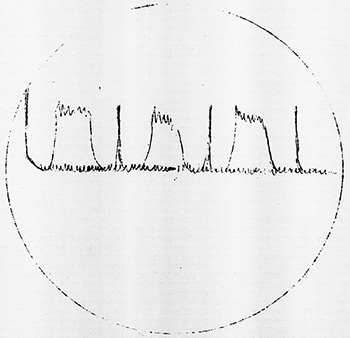
The SD radar was erratic and undependable from the beginning of the patrol. Four days out of Majuro it failed to pick up a medium bomber sighted at 6 miles, although it did pick up 23 Liberators at 25 miles a few days later. Both transmitter and receiver were thoroughly checked and found to be operating satisfactorily. From June 28, SD mast megger readings varied from 3000 ohms to infinity. Until July 15, the date of the final failure, readings were brought up to an acceptable value by diligent cleaning. After this, 40,000 ohms was the maximum reading that could be obtained. Since the antenna output was therefore low, the SD was not used again.
The loss of the SD in the area is not considered a great handicap. We conducted a surface patrol without it, and apparently sighted all planes before we were sighted (none dropped any bombs). If the SD is not in use, at least there is no possibility of the enemy "DF ing" it.
Radar Interference
| No. | Date | Time | Lat. N. | Long. E. | Nature | True Bearing |
|---|---|---|---|---|---|---|
| 1. | 30 Jun. | 1210 (K) | 6-45 | 141-49 | Interference | - |
| 2. | 30 Jun. | 2345 | 7-40 | 140-07 | Interference | 230° |
| 3. | 2 Jul. | 1045 | 9-25 | 138-50 | Interference | - |
| 4. | 21 Jul. | 1950 (I) | 7-20 | 132-05 | Interference | 143° |
| 5. | 24-25 Jul. | 1930 | 6-00 | 132-10 | Interference | 060° |
| 6. | 25-26 Jul. | 1030 | 7-00 | 134-27 | Interference | 070° |
| No. | Est. Width ° or Sweep Rate |
SD SJ |
Friendly? | Remarks |
|---|---|---|---|---|
| 1. | - | SD | Enemy | See sketch in Remarks. |
| 2. | 50° | SJ | Friendly | Probably ALBACORE; 706 AY Magnetron in use. |
| 3. | - | SD | Enemy | See sketch in Remarks. |
| 4. | 50° | SJ | Friendly | BALAO; 706 AY Magnetron in use. |
| 5. | 50° | SJ | Friendly | BALAO; 706 AY Magnetron in use. |
| 6. | 360° | SJ | Friendly | Sg. from friendly DD; 706 AY Magnetron in use. |
Sound conditions both near the Palau Islands and offshore were fair to good.
South of Yap the night of July 5, our inability to hear the trawler at ranges greater than 2500 yards made evasion difficult.
Before leaving Majuro, a member of the Columbia Research Laboratory spoke to the officers and predicted that large gradients would be found in southern waters at this time of year, and digests of other patrols indicated likewise. However, the largest total drop in temperature encountered in the Palau areas was 3° to 300 feet.
During both the surface patrolling and the few days spent submerged, the boat was very comfortable. While submerged, the ventilation system was rigged as recommended by ComSubPac (letter FF12-10/S38/(70) Serial 1045 of 30 May 1944). This method was found to be an improvement over the usual method of ventilation.
Except for one wounded prisoner, one case of cellulitis, and one case of eye strain (9 man days lost) were the pharmacist mate's only worries. One of the Japanese prisoners, however, had numerous shrapnel wounds, some serious, and kept the pharmacist mate occupied during the return from station.
The food was palatable and well-prepared throughout the patrol.
The training program this patrol was similar to that employed last patrol. The unqualified men were divided into small sections and each section was turned over to one of the unqualified officers for instruction. This method has proved advantageous to both the men and officers.
The five unqualified officers rotated their watches among a coding watch, night conning tower watch, and the three junior officer of the deck watches.
Enroute to the area and on the return voyage, training dives, controllerman drills, and fire control drills were held daily.
| Number on board | 70 |
|---|---|
| Number qualified at start | 46 |
| Number attempting qualification | 12 |
| Number qualified at end | 52 |
| Number advanced in rating | 9 |
| Number first patrol men | 10 |
| Majuro to Area | 2030 Miles | 18767 Gallons |
|---|---|---|
| In Area | 6182 Miles | 39791 Gallons |
| Area to Pearl | 3382 Miles | 42113 Gallons |
| Midway to Pearl | 1300 Miles | 20400 Gallons |
| Total | 12894 Miles | 121071 Gallons |
| Days Enroute to Area | 6 |
|---|---|
| Days in Area | 31 |
| Days Enroute to Base | 14 |
| Days Submerged | 8 |
| Torpedoes | 20 |
|---|---|
| Fuel (at Midway) | 13723 gallons |
| Provisions | 14 days |
| Personnel | 21 days |
Limiting Factor of This Patrol:
Operation order.
1. Lifeguard Communications
Drum conducted two separate lifeguard missions during the patrol; one with the Army at Yap, the other with the Navy during the carrier strike on Palau.
During the Palau strikes, voice communications left nothing to be desired. We were fully informed of the situation at all times. In addition, we were able to work well in conjunction with the BALAO, who was stationed some 25 miles southwest.
The communications with the Army at Yap over a period of seven days were pitiable. Although voice transmissions were heard frequently during the strikes, no communication could be established with the planes in spite of our attempts on two different days.
Had communication been successfully made on July 3, 1944, Drum probably would not have been strafed by the enemy fighter. The Liberators must have seen us, since they were only 3 miles off when we were forced down. Yet, with one plane smoking, and possibly in trouble, they made no apparent effort to apprise us of the situation.
Further, on July 6, 1944, twenty-four planes were sighted returning from Yap, while Drum was searching for aviators reported down. (Which information came to us from ComSubPac). We made an attempt to get the aid of the Liberators in our search but received no answer. One plane for a half-hour would have searched more area than we covered in 2 days.
Although I have given the matter much thought, I fail to understand the utter lack of coordination and cooperation on the part of the planes during this lifeguard mission.
2. Photography
While Drum was lifeguarding on the surface off Palau on July 26 and 27, 1944, several panoramic pictures were taken of the islands.
Pictures of Angaur, Peleliu, Eil Mald, Urukthapel, and Babelthuap Islands were taken at ranges varying from 5 to 3 miles both through the periscope and from topside.
Although several boats have reported difficulty in piloting the vicinity of Malakal Passage (and we had some the one day we were submerged there), no trouble whatsoever was experienced in identifying the landmarks while on the surface.
It is hoped that the photographs will show the landmarks plainly enough to be of some help to the boats who may still patrol the Palau areas.
3. Contacts
This is the second successive patrol during which no contact worthy of that name has been made. This patrol a 500 ton yard oiler was the largest ship sighted. Last patrol one 1900 ton ship and two 1200 ton ships were sighted.
Though morale remains high, it cannot continue to do so, unless "battle stations" is heard more frequently. Four officers and twenty-eight men have never heard a depth charge dropped close aboard with a "Drum tag" on it.
4. Sketch of Interference on SD Screen
(See paragraph M)
| Previous Patrol | Back to top? | Next Patrol |