
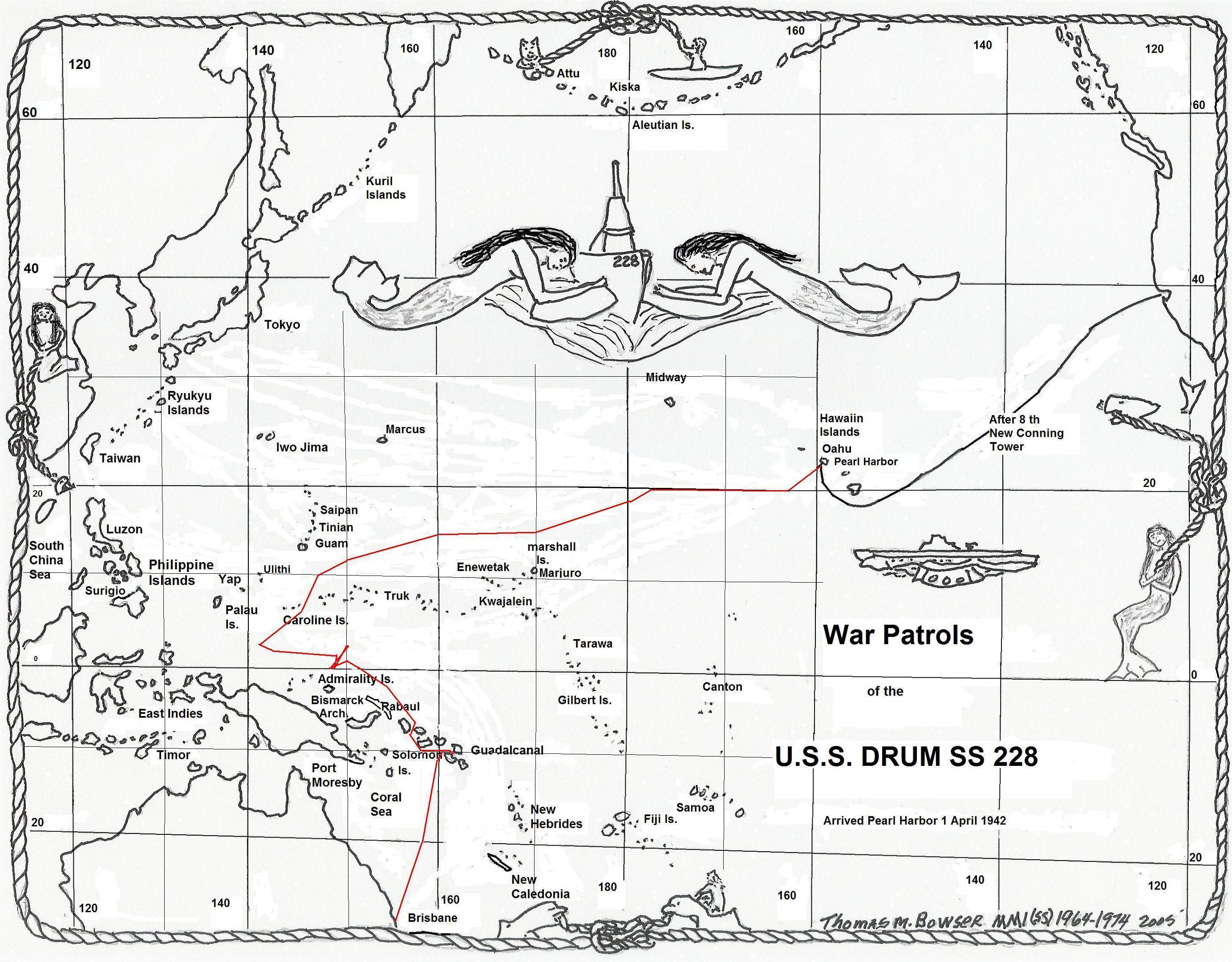
| Date | Name of Vessel |
Type of Vessel |
Tonnage JANAC |
Tonnage Alden |
Location | Assessment JANAC |
Assessment Alden |
|---|---|---|---|---|---|---|---|
| 17 November 1943 | Hie Maru | Submarine Tender | 11,621 | 11,621 | 1-48N, 148-24E | Sunk | Sunk |
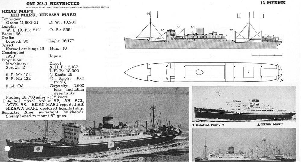
Image courtesy of History on CD-ROM.
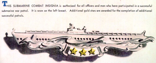
Award of Submarine Combat Insignia for this patrol is authorized.
(A) Prologue
(B) Narrative
(C) Weather
(D) Tidal Information
(E) Navigational Aids
(F) Ship Contacts
(G) Aircraft Contacts
(H) Attack Data
(I) Mines
(J) Anti Submarine Measures and Evasive Tactics
(K) Major Defects and Damage
(L) Radio
(M) Radar
(N) Sound Gear and Sound Conditions
(O) Density Layers
(P) Health, Food, and Habitability
(Q) Personnel
(R) Miles Steamed - Fuel Used
(S) Duration
(T) Factors of Endurance Remaining
(U) Remarks
Returned from seventh war patrol 6 October, 1943. Normal refit by the Submarine Repair Unit at Brisbane, Australia. Docked for painting, 22-23 October, 1943. Four days intensive training with U.S.S. PC 1123 and U.S.S. COUCAL, including gun firing practice approaches submerged, and radar approaches submerged and surfaced. Ready for sea: 2 November, 1943.
| All times are "LOVE". | |
| 2 November | |
| 1100 | Underway from Submarine Base, Brisbane, Australia. |
| 1337-1530 | Conducted sound listening tests in Moreton Bay. |
| 1930 | Passed Cape Moreton light abeam to starboard and proceeded to sea independently. |
| PM | Sighted two allied convoys, one outbound, one inbound. Sighted HMAS AUSTRALIA conducting night battle practice. Sighted U.S.S. RAY and HMAS BENALLA conducting training exercises. |
| 1200 |
POSIT: Brisbane River
DIST: 10.0 FUEL: 60.0 |
| 3 November | |
| Cruising on the surface, enroute Tulagi. Conducted three training dives and held fire control drills. | |
| 1200 |
POSIT: LAT. 24-17.5 S. LONG. 155-00.5 E.
DIST: 287.6 FUEL: 2811 |
| 4 November | |
| Cruising on the surface. Conducted three training dives. Compensated control room magnetic compass. | |
| 1200 |
POSIT: LAT. 20-08.0 S. LONG. 157-05.5 E.
DIST: 296.4 FUEL: 2395 |
| 5 November | |
| Cruising on the surface. Conducted three training dives and held fire control drills. | |
| 1200 |
POSIT: 15-45.0 S. LONG. 157-33.0 E.
DIST: 295.3 FUEL: 2592 |
| 6 November | |
| 0655 |
Sighted and exchanged recognition signals with U.S. Navy TBF Avenger. (Aircraft Contact No. 1) (Lat. 12-09.5 S., Long. 157-41.0 E.). Conducted three training dives. |
| 1200 |
POSIT: LAT. 11-12.0 S. LONG. 157-44.0 E.
DIST: 298.4 FUEL: 2291 |
| 7 November | |
| 0220 | Sighted Russell Islands, distant 30 miles. |
| 0510 | Sighted and exchanged recognition signals with escort, SC729, and proceeded to Tulagi Harbor. |
| 1045 | A five minute air raid alert held up fueling. |
| 1103 | Moored to oiler YOG-41, and commenced fueling. |
| 1310 | Took 12,458 gallons of diesel oil. |
| 1405 | Moored alongside U.S.S. ALCHIBA and filled all fresh water tanks. Anything else the ALCHIBA had was made available to us, but we were satisfied with the water alone. |
| 1507 | Underway in company with SC729. |
| 1900-1922 | Conducted trim dive, and sent escort back to Tulagi. |
| 1200 |
POSIT: Tulagi Harbor
DIST: 251.6 FUEL: 2091 |
| 8 November | |
| Cruising on the surface enroute area. | |
| 0705 | Sighted a small skiff awash in Lat. 6-45.0 S., Long. 158-55.0 E. |
| 1800-1814 | Conducted trim dive. |
| 1814 | Sighted Bougainville Island bearing 235°(T), distant 100 miles. |
| 1200 |
POSIT: LAT. 6-13.0 S. LONG. 158-02.5 E.
DIST: 301.6 FUEL: 2416 |
| 9 November | |
| 1800-1835 | Trim dive. |
| 1900 | Arrived in area, and commenced surface patrol at 10 knots. |
| 1200 |
POSIT: LAT. 2-10.0 S. LONG. 155-04.0 E.
DIST. 356.6 FUEL: 3278 |
| 10 November | |
| 1115 | Sighted large plane bearing 075°(T), distant 12 miles. (Aircraft Contact No. 2) (Lat. 1-04.0 N., Long. 151-43.0 E.). Avoided detection by turning away and slowing to 5 knots. |
| 1235 | Sighted one two engine bomber (Sally) bearing 060°(T), distant 6 miles. (Aircraft Contact No. 3) (Lat. 1-05.5 N., Long. 151-29.0 E.). |
| 1236 | Submerged and serviced torpedoes. |
| 1441 | Surfaced and resumed patrol at 10 knots. |
| 1200 |
POSIT: LAT. 1-07.5 N., LONG. 151-34.0 E.
DIST: 342.5 FUEL: 2810 |
| 11 November | |
| 0605 | Sighted convoy bearing 030°(T), distant 18,000 yards in early dawn. (Contact No. 1) (Lat. 00-20.0 N., Long. 148-35.0 E.). |
| 0608 | Submerged and commenced the approach. |
| 0614 | Manned battle stations submerged. (Attack No. 1) (Lat. 00-19.0 N., Long. 148-40.0 E.). |
| 0625 | Identified the convoy as three large transports with three escorting destroyers. |
| 0710-23" | Fired #1 tube. |
| 0710-29" | Fired #2 tube. |
| 0710-36" | Fired #3 tube. |
| 0710-43" | Fired #4 tube. |
| 0710-45" | Premature explosion, #1 torpedo, at 500 yards. |
| 0710-50" | Fired #5 tube. |
| 0710-56" | Fired #6 tube. |
| 0711 | Went deep, and commenced evasive action. |
| 0711-25" | #2 torpedo hit. |
| 0711-33" | #3 torpedo hit. |
| 0716-30" | First of four depth charges. |
| 0726 | Last depth charge, two of which were close aboard, overhead. No damage. |
| 0815 | At periscope depth, sighted one Asashio or Shigure class destroyer bearing 115°(T), distant 5000 yards conducting a routine supersonic search. |
| 1009 | Reload completed. Changed course to close destroyer for attack. |
| 1045 | Sighted destroyer bearing 125°(T), distant 20,000 yards, angle on the bow 180°. |
| 1115 | Surfaced and commenced search of area of attack. |
| 1230 | Sighted two depth charge marker buoys near debris and scum from the depth charging, but no wreckage or oil. Sent contact report. |
| 1300 | Cleared the area heading for center of assigned area. |
| 1200 |
POSIT: LAT. 00-20.0 N. LONG. 148-38.0 E.
DIST: 243.9 FUEL: 1715 |
| 12 November | |
| 0450 | Sighted a submarine on the surface, bearing 335°(T), distant 5000 yards. (Contact No. 2) (Lat. 1-58.0 N., Long. 149-04.0 E.). |
| 0452 | Submerged. |
| 0505 | Identified submarine as friendly. It was probably the ALBACORE. |
| 0512 | Submarine disappeared, either submerging or turning away. |
| 0520-0525 | Attempted to exchange recognition signals by underwater sound, but obtained no answers to our challenges. |
| 0745 | Surfaced and resumed 10 knot patrol. |
| 1200 |
POSIT: LAT. 2-16.5 N. LONG. 149-38.5 E.
DIST: 230.0 FUEL: 1338 |
| 13 November | |
| 0617-0700 | Trim dive. |
| 1010 | Sighted the mast and stack of a large ship resembling a tanker, bearing 112°(T), distant 25,000 yards. (Contact No. 3) (Lat. 2-16.0 N., Long 149-20.0 E.). Commenced tracking to gain position ahead for submerged attack. |
| 1030 | Lost contact with the ship and failed to regain it in spite of closing the estimated track at flank speed. The visibility became poor due to many rain squalls. Commenced a search of the possible escape courses, covering speeds up to 15 knots. |
| 1345 | Back tracked to cover slower speeds of the tanker, but found nothing. |
| 1715 | Set a course to arrive at estimated dawn position of the tanker, assuming he was headed for Truk. |
| 1200 |
POSIT: LAT. 2-27.0 N. LONG. 149-37.0 E.
DIST: 269.5 FUEL: 1896 |
| 14 November | |
| 0517-0534 | Trim dive. |
| 0630 | Arrived at estimated dawn position of the tanker. Commenced a search down his track. Results negative. |
| 0950 | Commenced searching to southward, on the Rabaul-Truk route, for a heavy cruiser damage by the SCAMP. |
| 2200 | Heard an explosion through the hull resembling a torpedo. (Lat. 2-21.0 N., Long. 149-35.0 E.). Stopped and listened for echo ranging, but heard nothing. |
| 2205 | Went ahead at five knots, manning sound. |
| 2400 | Resumed 10 knot patrol, sound search having revealed nothing. Hope the Japs finished off the cruiser for us! |
| 1200 |
POSIT: LAT. 4-11.5 N. LONG. 150-32.0 E.
DIST: 314.9 FUEL: 2590 |
| 15 November | |
| 0150 | Sighted two or three ships, probably men o'war, bearing 195°(T), distant 24,000 yards, in squally weather. (Contact No. 4) (Lat. 2-03.0 N., Long. 149-22.0 E.). Attempted to close and track them. Estimated their course 025°(T) to 050°(T), speed about 20 knots. |
| 0250 | Lost contact when the ships entered a heavy squall. Continued searching at high speed to no avail. |
| 0345 | Resumed 10 knot patrol toward last reported position of enemy cruiser. |
| 0521-0538 | Trim dive. |
| 1051 | Sighted one float biplane ("Pete"), bearing 240°(T), distant 6 miles. (Aircraft Contact No. 4) (Lat. 1-09.0 N., Long. 149-06.0 E.). Submerged. |
| 1130 | At 50 feet, picked up definite evidence of radar interference on the SD. |
| 1203 | Surfaced and continued search for wounded cruiser in the vicinity of 1-10.0 N., 149 E. Results negative. |
| 1200 |
POSIT: LAT. 1-08.0 N. LONG. 148-59.5 E.
DIST: 282.5 FUEL: 2060 |
| 16 November | |
| 0525-0539 |
Trim dive. Surface patrol at 10 knots. |
| 1200 |
POSIT: LAT. 2-27.0 N. LONG. 149-45.5 E.
DIST: 268.7 FUEL: 1549 |
| 17 November | |
| 0310 | Sighted a surfaced submarine bearing 225°(T), distant 5000 yards. (Contact No. 5) (Lat. 1-34.0 N., Long. 150-02.0 E.). This probably was the SCAMP. He sighted us about the same time, and both turned away and cleared the area. |
| 0525-0543 | Trim dive. |
| 0955 |
Sighted two float biplanes ("Petes"), bearing 255°(T), distant 6 miles on a northerly course. (Aircraft Contact No. 5) (Lat. 1-35.0 N., Long. 149-02.0 E.). Submerged to avoid detection. |
| 1015 | Surfaced. |
| 1140 | Sighted smoke of three ships, bearing 205°(T), distant 24,000 yards. (Contact No. 6) (Lat. 1-34.0 N., Long. 148-37.0 E.). Commenced tracking using the low periscope. Determined base course, 345°(T); speed 7.5 knots; convoy consisted of three marus and two escorts. |
| 1327 | Submerged. Manned battle stations submerged. (Attack No. 2) (Lat. 1-48.0 N., Long. 148-24.5 E.). |
| 1440-15" | Fired #1 tube. |
| 1440-22" | Fired #2 tube. |
| 1440-29" | Fired #3 tube. |
| 1440-35" | Fired #4 tube. |
| 1440-40" | Went deep and commenced evasive action. |
| 1441-26" | #3 torpedo hit. |
| 1444 | First of three depth charges. Paint chips and bits of cork were knocked loose. |
| 1447-17" | End of torpedo run explosion. |
| 1448 | String of twelve depth charges, fairly close, in pairs and singly. |
| 1503 | Last depth charge. A total of 15 charges were dropped, but they caused no damage. |
| 1550 | At periscope depth, sighted the damaged ship, bearing 075°(T), distant 12,000 yards, listed about 20° to port; one escort between us and the ship; and two columns of smoke to the northward. Commenced closing for kill. |
| 1700 | Another maru and the second escort are lying to near the damaged ship, range 9000 yards. Apparently they plan to tow the damaged ship, or to remove personnel should she sink. The other escort is now well to the south, conducting a routine supersonic search. |
| 1915 | Two distant explosions, apparently depth charges, but no escorts were in sight at the time. The third maru, which had been cruising at slow speed beyond the damaged ship, proceeded southward with one escort. |
| 1920 | Could not close the damaged ship by dark. Decided to pull clear, surface, and return to finish off the damaged ship, (and possibly the other ship also) using radar. |
| 2005 | Surfaced, and commenced closing the target group. |
| 2050 | Made contact on an escort bearing 090°(T), distant 3500 yards. |
| 2053 | The escort flashed the letter "A" at us, having made a radar or a sound contact, since the visibility was exceptionally poor and we had our tail toward him. Commenced a search of the area near the escort to locate the damaged ship. |
| 2359 |
Completed the search and found nothing. It is believed that the damaged ship sank between our last look at about 1930 and our return to the area at 2050. Commenced search along the probable route of the remaining ships of the convoy. |
| 1200 |
POSIT: LAT. 1-33.0 N. LONG. 148-33.0 E.
DIST: 261.0 FUEL: 1498 |
| 18 November | |
| 0833 |
Sighted smoke bearing 021°(T), distant 15,000 yards. (Contact No. 7) (Lat. 3-03.0 N., Long. 148-37.0 E.). Commenced closing and tracking. |
| 0842 | Lost contact when the "BLACKFISH" submerged, but we did not realize it was a submarine. Ran at flank speed and attempted to regain contact. |
| 1005 | Broke off chase and resumed 10 knot patrol. |
| 1115 |
Sighted a submarine bearing 108°(T), distant 18,000 yards. (Lat. 3-25.0 N., Long. 148-35.0 E.). Commenced closing. |
| 1132 | Submerged and continued closing the submarine. |
| 1220 | Determined that the submarine had also submerged. Changed course to southward, went deep and serviced all torpedoes. |
| 1510 | Surfaced. |
| 1656 | Sighted and exchanged recognition signals with the "BLACKFISH". The whole story was now clear. It was obvious that all our contacts today were with the "BLACKFISH"; and that we roared by him at about 0900, making 19 knots. Closed the BLACKFISH and asked that he remain in company until we tuned our radar with its new magnetron. He did likewise. |
| 1945 | Parted company with BLACKFISH with both radars in better condition. |
| 1200 |
POSIT: LAT. 3-24.0 N. LONG. 148-35.0 E.
DIST: 214.3 FUEL: 1716 |
| 19 November | |
| 0958 | Sighted the masts of three ships, bearing 061°(T), distant 20,000 yards. (Contact No. 8) (Lat. 1-16.0 N., Long. 149-34.0 E.). Tracked at high speed on the surface. Determined the course as 170°(T), speed as 7 knots. We were about 8 miles from the track at the time of sighting. |
| 1045 | Sighted one two-engine bomber ("Sally") bearing 130°(T), distant 5 miles. (Aircraft Contact No. 6) (Lat. 1-05.0 N., Long. 149-39.0 E.). Submerged and commenced closing the track at high speed. |
| 1210 |
Identified convoy, much to our disappointment, as three 100-300 ton trawlers, one with a small landing barge in tow, and four small motor sampans. Discontinued the approach at 4000 yards, when guns of about 6 pound caliber were seen mounted on the trawlers. Decided not to use the deck gun in view of: (1) The trawlers' guns; (2) the small value of the targets; (3) the presence of aircraft; (4) the unnecessary revelation of our position. |
| 1357 | Surfaced and resumed 10 knot patrol. |
| 1425 | Sighted a very large unidentified plane bearing 280°(T), distant 15 miles. (Aircraft Contact No. 7) (Lat. 1-10.0 N., Long. 149-48.0 E.). Avoided detection by turning away and slowing to five knots. This plane was headed south. |
| 1200 |
POSIT: LAT. 1-03.0 N. LONG. 149-42.0 E.
DIST: 253.6 FUEL: 1897 |
| 20 November | |
| 1215-1310 | Submerged during a violent rain squall. |
| 1200 |
POSIT: LAT. 2-20.0 N. LONG. 148-35.0 E.
DIST: 210.1 FUEL: 1475 |
| 21 November | |
| Patrolling to the westward at standard speed. | |
| 1200 |
POSIT: LAT. 2-44.0 N. LONG. 144-49.5 E.
DIST: 290.0 FUEL: 1931 |
| 22 November | |
| 0250 | Evidence of an SJ radar in the vicinity present on our screen. This remained until the radar was secured at daylight. Believe BLACKFISH was astern of us and that the interference was caused by his SJ. |
| 0531-0549 | Trim dive. |
| 0907 | Sighted smoke of three ships bearing 307°(T), distant 30,000 yards. Commenced tracking on the surface. Determined convoy to consist of four marus, on base course 130°(T). (Contact No. 9) (Lat. 2-53.0 N., Long. 141-33.0 E.). |
| 1003 | Submerged and commenced the approach. |
| 1042 | Manned battle stations submerged. (Attack No. 3) (Lat. 3-00.0 N., Long. 141-33.0 E.). |
| 1137-39" | Fired #1 tube. |
| 1137-45" | Fired #2 tube. |
| 1137-52" | Fired #3 tube. |
| 1137-58" | Fired #4 tube. |
| 1138-30" | Went deep and commenced evasive tactics. |
| 1139-45" | First of three small explosions. |
| 1142-15" | Heavy explosions, possibly end of torpedo run explosion. |
| 1143-20" | Second heavy explosion. |
| 1215 | Returned to periscope depth and sighted the four freighters lying to bearing 155°(T) to 180°(T), distant 4000 to 5000 yards, on headings between 270°(T) and 290°(T). None were visibly damaged, however. The two PC boats were between the Drum and the freighters, distant about 2500 yards, conducting a routine supersonic search. |
| 1225 | At deep submergence, having seen one PC boat heading in our general direction. |
| 1243 | First of four 600 pounders, close! |
| 1312 | Escort passed overhead from the starboard quarter. His screws were plainly audible through the hull. |
| 1313 | Four more big ones, really close, overhead abaft the conning tower. The most serious damage these caused was a crack in the conning tower door frame and plating. See paragraph (K) for all the details. |
| 1325 | Three 300 pound charges, farther away. Total 11. |
| 1630 | At periscope depth, nothing in sight, though the echo ranging was still audible bearing 245°(T). |
| 1752 | Surfaced. Headed northeast to send contact report and to report the crack in the conning tower. |
| 1900 | Changed course to attempt to regain contact with the convoy and trail it. |
| 2107 | Received orders to pull clear. |
| 1200 |
POSIT: LAT. 3-02.0 N. LONG. 141-35.0 E.
DIST: 248.9 FUEL: 1418 |
| 23 November | |
| 0105 | Received orders to head for Pearl Harbor. Set course 024°(T). |
| 1100 | Passed to operational control of Commander Submarine Pacific, having been under CTF-72 since 1 April 1943. |
| 1200 |
POSIT: LAT. 5-29.0 N. LONG. 144-04.0 E.
DIST: 272.2 FUEL: 2606 |
| 24 November | |
| 0001 | Picked up indications on the ARC of a radar station, probably on Olimarao Islands, Lat. 7-40.0 N., Long. 145-47.0 E. Went to four engine speed to be well clear of the area by dawn. |
| 1200 |
POSIT: LAT. 10-15.0 N. LONG. 146-50.0 E.
DIST: 342.1 FUEL: 3933 |
| 25 November | |
| 0548-0606 | Trim dive. |
| 1800 | All hands enjoyed an excellent Thanksgiving Dinner, right down to ice cream, pie and cake for dessert. |
| 1200 |
POSIT: LAT. 13-11.5 N. LONG. 150-29.0 E.
DIST: 316.6 FUEL: 3266 |
| 26 November | |
| 0800-0830 | Trim dive. |
| 1200 |
POSIT: LAT. 14-28.0 N. LONG. 155-08.0 E.
DIST: 309.1 FUEL: 3219 |
| 27 November | |
| 0100 | Changed to -12 zone time. |
| 0616-0630 (m) | Trim dive. |
| 1200 (m) |
POSIT: LAT. 15-45.5 N. LONG. 159-44.5 E.
DIST: 306.9 FUEL: 3243 |
| 28 November | |
| 1255-1318 (m) | Trim dive. |
| 1200 (m) |
POSIT: LAT. 17-03.0 N. LONG. 164-24.0 E.
DIST: 304.1 FUEL: 3335 |
| 29 November | |
| 0806-0825 (m) | Trim dive. |
| 1200 (m) |
POSIT: LAT. 17-59.0 N. LONG. 169-24.0 E.
DIST: 294.6 FUEL: 3181 |
| 30 November | |
| 0630-0639 (m) | Trim dive. |
| 1200 (m) |
POSIT: LAT. 18-51.0 N. LONG. 174-05.0 E.
DIST: 287.9 FUEL: 3289 |
| 1 December | |
| 0610-0623 (m) | Trim dive. |
| 1530 (m) | Crossed the International Date Line. Changed to -12 zone time and the date to 30 November, 1943. |
| 1200 (m) |
POSIT: LAT. 19-36.5 N. LONG. 179-11.0 E.
DIST: 304.9 FUEL: 3301 |
| 30 November | |
| 2200 (Y) | Changed to -11 zone time. |
| 1 December | |
| 0806-1012 (x) | Trim dive. |
| 1200 (x) |
POSIT: LAT. 20-22.5 N. LONG. 175-52.5 W.
DIST: 287.2 FUEL: 2882 |
| 2 December | |
| 0400 | Changed to -10 zone time. |
| 1208-1220 (w) | Trim dive. |
| 1200 |
POSIT: LAT. 20-33.0 N. LONG. 171-21.5 W.
DIST: 277.6 FUEL: 2306 |
| 3 December | |
| 0808-0820 (w) | Trim dive. |
| 1200 |
POSIT: LAT. 20-38.5 N. LONG. 166-53.5 W.
DIST: 260.0 FUEL: 3128 |
| 4 December | |
| 1200 (w) |
POSIT: LAT. 20-50.0 N. LONG. 161-31.5 W.
DIST: 304.7 FUEL: 3221 |
| 5 December | |
| 0200 (w) | Changed to -9.5 zone time. |
| 0615 (VW) | Sighted and exchanged recognition signals with SCORPION. |
| 0642 |
Sighted and exchanged recognition signals with escort, PC586. Proceeded at full speed to Pearl Harbor. |
| AM | Sighted friendly planes. |
| 1100 | Moored to Submarine Base, Pearl Harbor, T.H. |
There were fewer glassy days than previously experienced in the area between the Bismarck Archipelago and the Caroline Islands between longitudes 155° E. and 140° E. In general, the visibility was good both during the day and at night.
However, from the tenth to the sixteenth of November, a weather front was present near 4° North, moving slowly south to about 2° North. Squalls were frequent during this period and twice hindered the search for ships after contact had been made.
In the equatorial region between longitudes 140° East to 152° East, a current setting 285°(T), varying from one-half to one knot was experienced during the entire time in the area. The force and direction of the wind had little effect on this current.
None sighted.
| No. | Date | Time | Lat. North |
Long. East |
Description | Course | Masthead | Init. Range | Min. Range | Speed RPM |
Contact By | Remarks |
|---|---|---|---|---|---|---|---|---|---|---|---|---|
| 1. | 11 Nov. | 0605 (L) | 0-20 | 148-35 | 3 Transports 3 Destroyers |
165°(T) | 110 ft. | 18,000 yds. | 1750 yds. | 7 knots 100 RPM |
L.L. | Attack No. 1 |
| 2. | 12 Nov. | 0450 (L) | 1-58 | 149-04 | 1 Submarine | 040°(T) 210°(T) |
- | 5000 yds. | 2000 yds. | 7 knots | H.L. | Probably U.S.S. ALBACORE |
| 3. | 13 Nov. | 1015 (L) | 2-16 | 149-20 | Tanker | 025°(T) | - | 25,000 yds. | 25,000 yds. | - | L.L. | Lost contact on attempted end around. |
| 4. | 15 Nov. | 0150 (L) | 2-03 | 149-22 | 3 Warships | 025°- 050°(T) |
- | 25,000 yds. | 20,000 yds. | High | L.L. | Lost in a rain squall. |
| 5. | 17 Nov. | 0310 (L) | 1-34 | 150-02 | 1 Submarine | East | - | 5000 yds. | 5000 yds. | - | H.L. | Probably U.S.S. SCAMP |
| 6. | 17 Nov. | 1140 (L) | 1-34 | 148-37 | 3 Freighters 2 PC Boats |
345°(T) | 95 ft. | 24,000 yds. | 1000 yds. | 7.5 knots 100 RPM |
L.L. | Attack No. 2 |
| 7. | 18 Nov. | 0833 (L) | 3-03 | 148-37 | 1 Submarine | - | - | 15,000 yds. | Rendezvous | - | H.P. | U.S.S. BLACKFISH |
| 8. | 19 Nov. | 0958 (L) | 1-16 | 149-34 | 3 Trawlers 4 Motor Sampan 1 Barge |
170°(T) | - | 20,000 yds. | 4000 yds. | 7 knots | H.P. | Not worth torpedo. |
| 9. | 22 Nov. | 0907 (L) | 2-53 | 141-36.5 | 4 Freighters 2 PC Boats |
130°(T) | 95 ft. | 30,000 yds. | 2000 yds. | 7.5 knots 80 RPM |
L.P. | Attack No. 3 |
NOTE:
(1) Under "Contact By":
H.P. indicates High Periscope
L.P. indicates Low Periscope
H.L. indicates Sheers Lookout
L.L. indicates Lookout or OOD
(2) The RPM listed are for the ships chosen as the target for attack.
| No. | Date | Time | Lat. | Long. East |
Description | Course | Altitude | Max. Range | Min. Range | Contact By | Remarks |
|---|---|---|---|---|---|---|---|---|---|---|---|
| 1. | 6 Nov. | 0655 (L) | 12-09 S. | 157-41 | USN TBF Avenger | 210° | 1000 ft. | 6 miles | 0 | S.S. | Exchanged signals |
| 2. | 10 Nov. | 1115 (L) | 1-04 N. | 151-43 | Large Uniden | North | 1000 ft. | 12 miles | 12 miles | S.S. | Turned away & reduced speed. |
| 3. | 10 Nov. | 1235 (L) | 1-05.5 N. | 151-29 | 1 "Sally" | South | 10,000 ft. | 6 miles | 6 miles | S.S. | Not sighted - dove. |
| 4. | 15 Nov. | 1051 (L) | 1-09 N. | 149-06 | 1 "Pete" | 340° | 1000 ft. | 6 miles | 6 miles | S.S. | Dove. |
| 5. | 17 Nov. | 0955 (L) | 1-35 N. | 149-02 | 2 "Petes" | 025° | 2000 ft. | 6 miles | 6 miles | S.S. | Dove. |
| 6. | 19 Nov. | 1045 (L) | 1-05 N. | 149-39 | 1 "Sally" | 320° | 5000 ft. | 5 miles | 5 miles | S.S. | During chase - dove. |
| 7. | 19 Nov. | 1425 (L) | 1-10 N. | 149-48 | Large Uniden | South | 1000 ft. | 15 miles | 15 miles | S.S. | Turned away & reduced speed. |
NOTE:
(1) Under "Contact By":
SS indicates sighted while on the surface.
U.S.S. DRUM, Torpedo Attack No. 1, Patrol No. 8
Time: 0710 (L) Date: 11 November 1943 Lat. 0-19.0 N., Long. 148-40.0 E.
Target Data - Damage Inflicted
Description:
Three transports in column (form DOG), escorted by three destroyers, one on port bow of leading ship, one on port quarter of last ship, one on starboard beam of second ship. The leading ship was an 8000-9000 ton KMFKM freighter-transport; the second ship, the target, was a 11,000-12,000 ton passenger ship; the third ship was not well identified, but was about 6000-7000 tons. The convoy was sighted prior to dawn on the surface. Submerged and closed track in growing light. Attack made in glassy sea one-half hour after sunrise.
Ships Sunk:
None.
Ships Damaged:
One 11,000-12,000 ton passenger ship similar to Yasukuni Maru (11,930 tons) (MFM).
Damage Determined By:
(1) Hearing two torpedo explosions 56 sec. and 57 sec. after firing #2 and #3 torpedoes
(2) The time of run of these torpedoes gives a range of 1500 yards, while the estimated range was 1750 yards. The explosions sounded similar to, but were more distant than the premature explosion of No. 1 torpedo which was seen about 500 yards ahead of the Drum.
Target Draft 25 feet, Course 190°(T), Speed 7 knots, Range 1750 yds.
Own Ship Data:
Speed 3 knots, Course 110°(T), Depth 64 ft., Angle 0°
Fire Control and Torpedo Data
Type Attack
Sighted convoy on the surface and submerged at about 18,000 yards. Closed the track of the target group, which was zig-zagging on 8 to 10 minute legs. When the range was 3800 yards, 3600 yards to the track, the target group changed course 25 degrees toward us, presenting a favorable attack opportunity.
A spread of 1.5 degrees between the torpedoes was set using the offset dial.
Bearings were fed into the TDC during the firing of the first three torpedoes, after which the attention of the Commanding Officer was directed to the closest destroyer on the starboard bow.
There were no end of run explosions.
| Attack #1 | ||||||
|---|---|---|---|---|---|---|
| Tubes Fired | #1 | #2 | #3 | #4 | #5 | #6 |
| Track Angle | 103°S | 103°S | 103°S | 105°S | 103°S | 103°S |
| Gyro Angle | 3°R | 3°R | 3°R | 5°R | 3°R | 3°R |
| Depth Set | 15 ft. | 15 ft. | 15 ft. | 15 ft. | 15 ft. | 15 ft. |
| Power | High | High | High | High | High | High |
| Hit or Miss | Miss | Hit | Hit | Miss | Miss | Miss |
| Erratic? | Yes | No | No | No | No | No |
| Mark Torpedo | XIV-3A | XIV-3A | XIV-3A | XIV-3A | XIV-3A | XIV-3A |
| Serial No. | 24843 | 39798 | 22715 | 24831 | 24844 | 22713 |
| Mark Exploder | VI-1 | VI-1 | VI-1 | VI-1 | VI-1 | VI-1 |
| Serial No. | 6604 | 6599 | 14670 | 6314 | 6627 | 6585 |
| Actuation Set | Contact Magnetic |
Contact Magnetic |
Contact Magnetic |
Contact Magnetic |
Contact Magnetic |
Contact Magnetic |
| Actuation Actual | Premature | Contact | Contact | - | - | - |
| Mark Warhead | XVI | XVI | XVI | XVI | XVI | XVI |
| Serial No. | 1738 | 2647 | 1717 | 1702 | 1831 | 2683 |
| Explosive | TPX | TPX | TPX | TPX | TPX | TPX |
| Firing Interval | - | 6 sec. | 7 sec. | 7 sec. | 7 sec. | 7 sec. |
| Type Spread | 3 3/4°R | 2 1/4°R | 3/4°R | 3/4°L | 2 1/4°L | 3 3/4°L |
| DIVERGENT | ||||||
Sea conditions - glassy.
Overhaul activity - Subase Brisbane.
REMARKS:
(1) Torpedo #24843 (#1) exploded prematurely after 20 sec., at about 500 yards.
U.S.S. DRUM, Torpedo Attack No. 2, Patrol No. 8
Time: 1440 (L) Date: 17 November 1943 Lat. 1-48.0 N., Long. 148-24.5 E.
Target Data - Damage Inflicted
Description:
Three freighters in line of bearing, escorted by two PC boats (one was #33), one on port bow of leading ship, the other on starboard beam of last ship. The target was the leading ship (MFM), 5000 tons, passenger cargo type. The other two marus were 4500 ton (MKFM) and 4000 ton (MFM) types.
The convoy's smoke was sighted on the surface in good visibility. The attack was made in a choppy sea.
Ships Sunk:
One (MFM) passenger cargo type, similar to Naminoue Maru (4731 ton).
Ships Damaged:
None.
Damage Determined By:
(1) Hearing one torpedo explosion 57 sec. after firing the third torpedo.
(2) Seeing the ship lying to, with a 20° list to port.
(3) Finding no trace of damaged ship at 2045 (L) in spite of closing point where ship was last sighted lying to at 1930 (L).
Target Draft 18 feet, Course 018°(T), Speed 7.5 knots, Range 1350 yds.
Own Ship Data:
Speed 2 knots, Course 160°(T), Depth 64 feet, Angle 0°
Fire Control and Torpedo Data
Type Attack
Sighted the convoy on the surface at about 24,000 yards. Tracked using #1 periscope and determined the base course as 345°(T), with the convoy zig-zagging on 7 minute legs from 010°(T) to 320°(T). Submerged 20,000 yards ahead of convoy and conducted a normal approach using the bow tubes.
Gained a position inside the port screen and fired four torpedoes at the leading and largest ship using a 2° offset dial spread between torpedoes, on a 35°P track, torpedo run 1350 yards. Firing bearings were fed into the TDC during the firing of all torpedoes. Drum was not detected prior to the explosion of the torpedo.
| Attack #2 | ||||
|---|---|---|---|---|
| Tubes Fired | #1 | #2 | #3 | #4 |
| Track Angle | 37°P | 36°P | 35°P | 34°P |
| Gyro Angle | 1 1/2°R | 2 1/2°R | 3 1/2°R | 4 1/2°R |
| Depth Set | 12 ft. | 12 ft. | 12 ft. | 12 ft. |
| Power | High | High | High | High |
| Hit or Miss | Miss | Miss | Hit | Miss |
| Erratic? | No | No | No | No |
| Mark Torpedo | XIV-3A | XIV-3A | XIV-3A | XIV-3A |
| Serial No. | 25555 | 25636 | 22710 | 22716 |
| Mark Exploder | VI-1 | VI-1 | VI-1 | VI-1 |
| Serial No. | 6326 | 6628 | 5614 | 6620 |
| Actuation Set | Contact Magnetic |
Contact Magnetic |
Contact Magnetic |
Contact Magnetic |
| Actuation Actual | - | - | Contact | - |
| Mark Warhead | XVI | XVI | XVI | XVI |
| Serial No. | 2609 | 2628 | 2630 | 1994 |
| Explosive | TPX | TPX | TPX | TPX |
| Firing Interval | - | 7 sec. | 7 sec. | 7 sec. |
| Type Spread | 3°L | 1°L | 1°R | 3°R |
| DIVERGENT | ||||
Sea conditions - choppy, no swell.
Overhaul activity - Subase, Brisbane, Aust.
Remarks:
A spread of 2° between torpedoes was used. 1° spread would have undoubtedly have produced two hits. One end of run explosion occurred 6 min. 02 sec. after firing the first torpedo.
U.S.S. DRUM, Torpedo Attack No. 3, Patrol No. 8
Time: 1337 (L) Date: 22 November 1943 Lat. 3-00.0 N., Long. 141-33.0 E.
Target Data - Damage Inflicted
Description:
Four freighters in two columns, escorted by two PC boats, one on either beam of the convoy. The target was the leading ship of the starboard column, and was a MFM well deck 5000 ton freighter. Two of the others were similar, while the fourth maru was about 3500 tons. The convoy's smoke was sighted on the surface in good visibility. The attack was made in a lightly rippled sea with a slight swell.
Ships Sunk:
None.
Ships Damaged:
Not determined.
Damage Determined By:
(1) The explosions which occurred cannot be reconciled as to time.
(2) The fact that all four freighters were lying to on the reverse of the base course one half hour after firing may indicated possible damage to one.
Target Draft 24 feet, Course 172°(T), Speed 7.5 knots, Range 2350 yds.
Own Ship Data:
Speed 2 knots, Course 240°(T), Depth 64 feet, Angle 0°
Fire Control and Torpedo Data
Type Attack
Sighted the smoke of the convoy on the surface at about 30,000 yards. Tracked, using #1 periscope, and determined the base course as 130°(T) with the convoy zig-zagging on 7-8 minute legs from 090°(T) to 170°(T). Submerged 22,000 yards ahead of convoy and conducted a normal approach using the bow tubes.
Gained a position between the two columns of the convoy, and fired four torpedoes at the leading ship in the starboard column using a 1 1/2° offset dial spread between torpedoes on a 118°P track at a range of 2350 yards, torpedo run, 2600 yards. Firing bearings were fed into the TDC during the firing. The target showed no indications of having sighted the Drum even after firing the torpedoes. However, the only explanation for the misses if misses is that the torpedoes were sighted and the target maneuvered to avoid.
| Attack #3 | ||||
|---|---|---|---|---|
| Tubes Fired | #1 | #2 | #3 | #4 |
| Track Angle | 118°P | 117°P | 117°P | 116°P |
| Gyro Angle | 6°L | 5°L | 5°L | 4°L |
| Depth Set | 16 ft. | 16 ft. | 16 ft. | 16 ft. |
| Power | High | High | High | High |
| Hit or Miss | Miss | MIss | Miss | Miss |
| Erratic? | No | No | No | No |
| Mark Torpedo | XIV-3A | XIV-3A | XIV-3A | XIV-3A |
| Serial No. | 39498 | 22711 | 39543 | 22714 |
| Mark Exploder | VI-1 | VI-1 | VI-1 | VI-1 |
| Serial No. | 5070 | 7303 | 6596 | 6625 |
| Actuation Set | Contact Magnetic |
Contact Magnetic |
Contact Magnetic |
Contact Magnetic |
| Actuation Actual | - | - | - | - |
| Mark Warhead | XVI | XVI | XVI | XVI |
| Serial No. | 2675 | 1762 | 1789 | 2631 |
| Explosive | TPX | TPX | TPX | TPX |
| Firing Interval | - | 6 sec. | 7 sec. | 6 sec. |
| Type Spread | 2°L | 3/4°L | 3/4°R | 2°R |
| DIVERGENT | ||||
Sea conditions - rippled, slight swell.
Overhaul activity - Subase, Brisbane, Aust.
Remarks:
(1) Two probable end of run explosions occurred 4 min. 36 sec. and 5 min. 41 sec. after firing the first torpedo.
None encountered.
Counter Attack #1
The expected heavy depth charging following attack no. 1 never materialized.
The convoy was escorted by three Asashio or Shigure type destroyers, one on the port bow, one on the port quarter, and one on the starboard beam of the column. They were echo ranging on 16, 16.5, and 17 kilocycles.
The premature explosion of the first torpedo gave the destroyers their first indication of the Drum's presence. All immediately ceased pinging and commenced a sound listening search. One distant depth charge was dropped five minutes after firing. Five minutes later a pair of close ones were dropped, and a minute later a parting shot, not close.
The three destroyers continued the search for about one half hour after which two left to rejoin the convoy. The third destroyer was seen echo ranging about 5000 yards astern one hour after the attack. No good contacts were obtained and maintained by any of the destroyers.
The sea was glassy, and a sharp gradient was noted at about 280 feet.
Evasive measures included running silent and gradually working away from the listening destroyers, leaving them well astern after one hour.
During the surface search of the area of the attack, two barrels with bamboo poles, attached (but no flags attached to poles) were sighted close to depth charge debris and foam.
Counter Attack #2
PC 33 and his pal did an excellent job of depth charging after attack no. 2.
The Drum attacked the leading ship from its port bow, going inside the escort undetected. Until the attack was made, the escorts echo-ranged on 16-20 kilocycles, using automatic keying, often shifting frequencies.
Two and a half minutes after the torpedo explosion, three depth charges exploded close overhead, jarring paint and bits of cork loose. Thereafter, the escorts maintained fair contact by listening and dropped twelve more charges, none as close as the first barrage. At 1510, one escort commenced echo ranging, but never regained contact.
One hour and ten minutes after firing, Drum commenced evading at periscope depth. Although the escort came within 2500 yards (close enough to see his "PC33"), he never made a contact.
Five hours after firing, two distant charges exploded but no escort was in sight at that time.
Counter Attack #3
The working over the PC's of attack no. 3 gave the Drum, put counter attack #2 to shame. This time the close ones were really close, and they were big!
The attack was executed from a position between the two columns of the convoy. The escorts did not know a submarine was present until numerous small and large explosions occurred after the torpedo firing. During the approach, both escorts echo-ranged on about 18 kilocycles, automatic keying, 8 second intervals.
Apparently the PC boats could not find the Drum in the melee of screws in close proximity to the convoy. For about one half hour, a supersonic search was conducted while Drum evaded at deep submergence to the northwestward, on the reverse of the convoy's base course. At that time Drum came to periscope depth to look things over.
The escorts were 2500 yards away between us and the convoy, which was apparently lying to on headings 270°(T) to 290°(T). While we were at periscope depth, one escort made sound contact and headed towards us, as we returned to deep submergence.
Twenty-eight minutes after our look four 600 pounders went off close aboard. One half hour later, one escort, having alternately listened and pinged, passed overhead just abaft the conning tower and dropped four more big ones. These were even closer than the first barrage and caused the damage listed in paragraph (K) (1).
Ten minutes later a parting shot of three 300 pounders went off farther away. After that, sound contact was not regained by the escorts who continued to listen and echo-range for about two hours, gradually pulling away.
The final evasion course was northeast, after having boxed the compass at various times during the counter attack. Six hours after the attack, four hours after the last barrage, Drum surfaced and found nothing in sight.
Sound conditions were exceptionally good. There was no temperature gradient to 300 feet.
(1.) Damage From #3 Depth Charge Attack
(a) Cracked the conning tower door frame at the upper hinge and the plating adjacent thereto for about four inches. Water entered at about two or three gallons a minute at deep submergence.
(b) Caused the port vent riser of #7 MBT to leak at a flange.
(c) Started the maneuvering room hard patch leaking again over the center of the main control cubicle. This was a weak spot prior to the refit following the second patrol when the U.S.S. FULTON succeeded in caulking the patch. No trouble had been experienced for about one year.
(d) Caused #5 and #6 impulse bottles to leak slightly.
(e) Deranged the low power system of #2 periscope.
(f) Deranged the target speed dial of TDC.
Damage From #2 Depth Charge Attack
(a) On several of the closer depth charges, the suction valve from the fuel oil collecting tank opened and allowed fuel to enter the after engine room in a fine spray. On the fourth such occasion, it refused to reseat, and about five hundred gallons of fuel oil went into the bilges. Heavy fumes permeated the after part of the ship. This valve was tested the following day at 275 feet and proved tight. It also held well during the heavier depth charging on 22 November, 1943.
(2.) Engineering
On two occasions November 9 and 26, #2 auxiliary engine failed to stop on diving. In both instances the engine was stopped by closing the outboard exhaust valve. This blew the gaskets on the explosion plates, but caused no other damage.
Both times the racks were found clean and showed no evidence of sticking.
(3.) Torpedoes
Torpedo #39804 flooded twice, having about six gallons of water in the afterbody each time.
Torpedoes #39601 and #22673 had about two pints in the afterbody.
In all cases the gyros were dry and no cause for flooding was apparent. The torpedoes were under pressure not over fifteen minutes.
Exploder #6604 functioned prematurely after twenty seconds of running. The depth setting was fifteen feet. The sea was glassy. The tube was flooded about one minute before firing.
No material casualties were experienced. Both Belconnen and NPM schedules were copied satisfactorily. All transmissions to Australian stations were successful.
(1.) SJ
The performance of the SJ during this patrol was poorer than during any previous patrols.
All material talent in the Brisbane area worked until sailing time to make the lobe switching operative. These efforts were unsuccessful. Thus in spite of operation of the lobe switching motor, the lobe switching unit failed to function properly at any time.
The magnetron installed in Brisbane was unstable and unreliable. On 18 November, a rendezvous with the BLACKFISH in the area permitted us to install and tune a new magnetron after which the SJ appeared more reliable, though the lobe switching unit was still inoperative.
(2.) SD
The operation of the SD was not consistent. Unstable plate voltage of the cathode ray tube is the apparent cause of this. A complete overhaul of the SD is necessary and has been requested during the present refit.
(3.) ARC-1
The ARC finally found an enemy radar, though efforts to do so on four previous patrols had been unsuccessful.
This radar probably was on Olimarao Islands, Lat. 7-40.0 N., Long. 145-47.0 E. Its frequency was 230 megacycles, pulse rate 900.
In the region near the equator between longitudes 152° E. and 140° E., sound conditions proved good. Three attacks were made, during two of which excellent sound conditions maintained. There was very little background noise present most of the time.
Screws of escorts and merchant vessels were heard at about 6000 yards on several occasions.
The sound gear functioned well throughout the patrol.
As usual, density layers were few and far between in the area between the Bismarck Archipelago and the Carolines.
The complete lack of any kind of layer during the depth charging of 22 November 1943 no doubt made the escorts' task considerably easier.
Several bathythermograph cards were taken during the patrol.
| Date | Lat. | Long. | Surface Temp. | Least Temp. | Gradient At |
|---|---|---|---|---|---|
| 10 Nov. | 0° | 149° E. | 87° | 83° | 230 ft. |
| 17 Nov. | 2° N. | 148° E. | 88° | 87° | - |
| 18 Nov. | 3° N. | 148° E. | 87° | 85° | 130 ft. |
| 22 Nov. | 3° N. | 141° E. | 88° | 87.5° | - |
Except for one slight case of heat prostration during the running silent period on 22 November 1943, the health of the crew was excellent.
The food was well prepared at all times. It was unfortunate, however, that no meat except beef and lamb were obtainable in Australia; nor were any fresh frozen vegetables or fruits available.
Since most of the patrol was spent on the surface, habitability was excellent. The supply of fresh potatoes in the forward torpedo room proved a breeding place for flies. The forward torpedo room waged an intensive, though losing, battle against them, finally resorting to the Admiral Halsey slogan, "KILL FLIES, KILL FLIES, KILL MORE FLIES, _______________ !"
The state of training and morale of the crew is good. In spite of long hours under glaring visibility conditions, the lookouts performed very well. The lack of casualties to material speaks well for the operating personnel.
Again, as on the seventh patrol, the caliber of the personnel obtained from the Submarine Base in Brisbane and the Submarine Division 82 proved high.
| Brisbane to Area | 2097.5 Miles | 17934 Gallons |
|---|---|---|
| In Area | 3672.0 Miles | 26499 Gallons |
| Area to Pearl Harbor | 3848.4 Miles | 40584 Gallons |
| Total | 9617.9 Miles | 85017 Gallons |
| Days Enroute to Area | 7 |
|---|---|
| Days in Area | 15 |
| Days Enroute to Pearl Harbor | 13 |
| Days Submerged | 0 |
| Torpedoes | 10 |
|---|---|
| Fuel | 20873 gallons |
| Provisions | 40 days |
| Personnel | 30 days |
Limiting Factor of This Patrol:
Damage sustained during depth charging ended the patrol.
Of the fifteen days on station, only thirty-seven hours eleven minutes were spent submerged. Of this time some twenty hours were during attacks and counter attacks.
It is significant to note that all six aircraft contacts in the area were in the vicinity of 1° N. Although much time was spent near 2° N., no planes were sighted in that locality.
| Previous Patrol | Back to top? | Next Patrol |